


10-Voting District 10, S Tropical Trl, Merritt Island, County, Brevard County, Florida
About
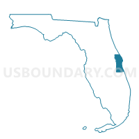
Outline

Summary
| Unique Area Identifier | 551243 |
| Name | 10-Voting District 10, S Tropical Trl, Merritt Island, County |
| County | Brevard County |
| State | Florida |
| Area (square miles) | 10.49 |
| Land Area (square miles) | 3.66 |
| Water Area (square miles) | 6.83 |
| % of Land Area | 34.86 |
| % of Water Area | 65.14 |
| Latitude of the Internal Point | 28.30202510 |
| Longtitude of the Internal Point | -80.67997640 |
Maps


Graphs
Select a template below for downloading or customizing gragh for 10-Voting District 10, S Tropical Trl, Merritt Island, County, Brevard County, Florida


Neighbors
Neighoring Voting District (by Name) Neighboring Voting District on the Map
- 100-Voting District 100, County, Brevard County, FL
- 102-Voting District 102, North of Suntree Blvd, RR to River, County, Brevard County, FL
- 11-Voting District 11, Central Merritt Island, County, Brevard County, FL
- 135-Voting District 135, S Tropical Trl, County, Brevard County, FL
- 19-Voting District 19, Merritt Island Area, County, Brevard County, FL
- 4-Voting District 4, Rockledge, Brevard County, FL
- 77-Voting District 77, County, Brevard County, FL
- 88.02-Voting District 88, Area 2, Cocoa Beach, Brevard County, FL
- 91-Voting District 91, PAFB, Brevard County, FL
Top 10 Neighboring County Subdivision (by Population) Neighboring County Subdivision on the Map
- Cocoa-Rockledge CCD, Brevard County, FL (117,219)
- Indialantic-Melbourne Beach CCD, Brevard County, FL (43,107)
- Merritt Island CCD, Brevard County, FL (42,611)
- Cocoa Beach-Cape Canaveral CCD, Brevard County, FL (23,408)
Top 10 Neighboring Place (by Population) Neighboring Place on the Map
Top 10 Neighboring Unified School District (by Population) Neighboring Unified School District on the Map
Top 10 Neighboring State Legislative District Lower Chamber (by Population) Neighboring State Legislative District Lower Chamber on the Map
Top 10 Neighboring State Legislative District Upper Chamber (by Population) Neighboring State Legislative District Upper Chamber on the Map
Top 10 Neighboring 111th Congressional District (by Population) Neighboring 111th Congressional District on the Map
Top 10 Neighboring Census Tract (by Population) Neighboring Census Tract on the Map
- Census Tract 694, Brevard County, FL (6,113)
- Census Tract 716, Brevard County, FL (4,415)
- Census Tract 628, Brevard County, FL (3,737)
- Census Tract 681.02, Brevard County, FL (3,300)
- Census Tract 693, Brevard County, FL (2,983)
- Census Tract 671, Brevard County, FL (1,222)