


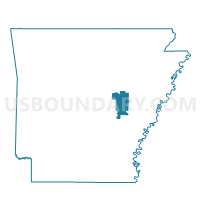
Calhoun Voting District, Prairie County, Arkansas
About
Outline

Summary
| Unique Area Identifier | 527768 |
| Name | Calhoun Voting District |
| County | Prairie County |
| State | Arkansas |
| Area (square miles) | 58.58 |
| Land Area (square miles) | 56.59 |
| Water Area (square miles) | 1.99 |
| % of Land Area | 96.60 |
| % of Water Area | 3.40 |
| Latitude of the Internal Point | 34.98151300 |
| Longtitude of the Internal Point | -91.43898740 |
Maps


Graphs
Select a template below for downloading or customizing gragh for Calhoun Voting District, Prairie County, Arkansas


Neighbors
Neighoring Voting District (by Name) Neighboring Voting District on the Map
- Brinkley TWP Voting District, Monroe County, AR
- Cotten Plant/Freeman Precinct 7, Woodruff County, AR
- Des Arc TWP Voting District, Prairie County, AR
- Gregory Precinct 6, Woodruff County, AR
- Upper Surrounded Hill Voting District, Prairie County, AR
- White River Voting District, Prairie County, AR
Top 10 Neighboring County Subdivision (by Population) Neighboring County Subdivision on the Map
- White River township, Prairie County, AR (2,247)
- Cotton Plant township, Woodruff County, AR (717)
- Calhoun township, Prairie County, AR (300)
- Des Arc township, Prairie County, AR (272)
- Upper Surrounded Hill township, Prairie County, AR (78)
- Freeman township, Woodruff County, AR (34)
- Garden township, Woodruff County, AR (17)
- Brown township, Monroe County, AR (1)
Top 10 Neighboring Unified School District (by Population) Neighboring Unified School District on the Map
- Brinkley School District, AR (4,479)
- Des Arc Public Schools, AR (3,596)
- Augusta School District, AR (3,558)
Top 10 Neighboring State Legislative District Lower Chamber (by Population) Neighboring State Legislative District Lower Chamber on the Map
- State House District 14, AR (25,762)
- State House District 57, AR (24,379)
- State House District 51, AR (23,525)
Top 10 Neighboring State Legislative District Upper Chamber (by Population) Neighboring State Legislative District Upper Chamber on the Map
Top 10 Neighboring 111th Congressional District (by Population) Neighboring 111th Congressional District on the Map
Top 10 Neighboring Census Tract (by Population) Neighboring Census Tract on the Map
- Census Tract 4901, Woodruff County, AR (4,486)
- Census Tract 9501, Monroe County, AR (3,787)
- Census Tract 4601, Prairie County, AR (3,763)
- Census Tract 4902, Woodruff County, AR (2,774)