


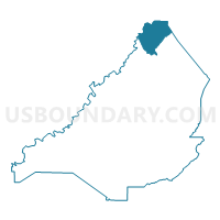
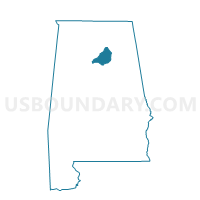
Summit, Blount County, Alabama
About
Outline

Summary
| Unique Area Identifier | 521238 |
| Name | Summit |
| County | Blount County |
| State | Alabama |
| Area (square miles) | 23.82 |
| Land Area (square miles) | 23.71 |
| Water Area (square miles) | 0.11 |
| % of Land Area | 99.52 |
| % of Water Area | 0.48 |
| Latitude of the Internal Point | 34.22106000 |
| Longtitude of the Internal Point | -86.47624260 |
Maps

Graphs
Select a template below for downloading or customizing gragh for Summit, Blount County, Alabama


Neighbors
Neighoring Voting District (by Name) Neighboring Voting District on the Map
- Brooksville, Blount County, AL
- Holly Pond Fire Dept., Cullman County, AL
- Joppa Volunteer Fire Dept, Cullman County, AL
- New Canaan, Cullman County, AL
- Rock Springs, Blount County, AL
- Valley Store Hwy 70, Marshall County, AL
- Warrenton Comm Center, Marshall County, AL
Top 10 Neighboring County Subdivision (by Population) Neighboring County Subdivision on the Map
- Guntersville CCD, Marshall County, AL (14,258)
- Baileyton-Joppa CCD, Cullman County, AL (5,582)
- Brooksville CCD, Blount County, AL (4,451)
Top 10 Neighboring Unified School District (by Population) Neighboring Unified School District on the Map
- Cullman County School District, AL (65,702)
- Blount County School District, AL (50,755)
- Marshall County School District, AL (47,197)
Top 10 Neighboring State Legislative District Lower Chamber (by Population) Neighboring State Legislative District Lower Chamber on the Map
Top 10 Neighboring State Legislative District Upper Chamber (by Population) Neighboring State Legislative District Upper Chamber on the Map
Top 10 Neighboring 111th Congressional District (by Population) Neighboring 111th Congressional District on the Map
Top 10 Neighboring Census Tract (by Population) Neighboring Census Tract on the Map
- Census Tract 306, Marshall County, AL (6,510)
- Census Tract 9641, Cullman County, AL (5,582)
- Census Tract 504, Blount County, AL (4,451)