


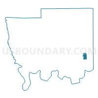
Camelia Baptist Church, Autauga County, Alabama
About
Outline

Summary
| Unique Area Identifier | 521154 |
| Name | Camelia Baptist Church |
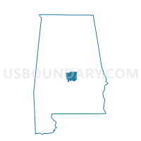
| County | Autauga County |
| State | Alabama |
| Area (square miles) | 1.95 |
| Land Area (square miles) | 1.95 |
| Water Area (square miles) | 0.00 |
| % of Land Area | 99.82 |
| % of Water Area | 0.18 |
| Latitude of the Internal Point | 32.47402430 |
| Longtitude of the Internal Point | -86.45970330 |
Maps

Graphs
Select a template below for downloading or customizing gragh for Camelia Baptist Church, Autauga County, Alabama


Neighbors
Neighoring Voting District (by Name) Neighboring Voting District on the Map
- Chamber of Commerce, Autauga County, AL
- Church of the Living Water, Autauga County, AL
- Prattmont Baptist Church, Autauga County, AL
- Trinity Methodist Church, Autauga County, AL
- Upper Kingston Community Center, Autauga County, AL
Top 10 Neighboring County Subdivision (by Population) Neighboring County Subdivision on the Map
Top 10 Neighboring Place (by Population) Neighboring Place on the Map
Top 10 Neighboring Unified School District (by Population) Neighboring Unified School District on the Map
Top 10 Neighboring State Legislative District Lower Chamber (by Population) Neighboring State Legislative District Lower Chamber on the Map
Top 10 Neighboring State Legislative District Upper Chamber (by Population) Neighboring State Legislative District Upper Chamber on the Map
Top 10 Neighboring 111th Congressional District (by Population) Neighboring 111th Congressional District on the Map
Top 10 Neighboring Census Tract (by Population) Neighboring Census Tract on the Map
- Census Tract 208.02, Autauga County, AL (10,435)
- Census Tract 204, Autauga County, AL (4,386)
- Census Tract 203, Autauga County, AL (3,373)
- Census Tract 207, Autauga County, AL (2,891)
- Census Tract 202, Autauga County, AL (2,170)