


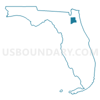
Clay County PUMA, Florida
About
Outline

Summary
| Unique Area Identifier | 192537 |
| Name | Clay County PUMA |
| State | Florida |
| Area (square miles) | 643.55 |
| Land Area (square miles) | 604.36 |
| Water Area (square miles) | 39.19 |
| % of Land Area | 93.91 |
| % of Water Area | 6.09 |
| Latitude of the Internal Point | 29.98711550 |
| Longtitude of the Internal Point | -81.85814720 |
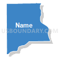
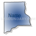
Maps

Graphs
Select a template below for downloading or customizing gragh for Clay County PUMA, Florida


Neighbors
Neighoring Public Use Microdata Area (by Name) Neighboring Public Use Microdata Area on the Map
- Columbia, Levy, Bradford, Gilchrist, Dixie & Union Counties PUMA, FL
- Duval County (Outer)--Jacksonville City (North & West) PUMA, FL
- Duval County (South Central)--Jacksonville City (Southeast River) PUMA, FL
- Duval County (Southwest Central)--Jacksonville City (Southwest) PUMA, FL
- Nassau & Baker Counties PUMA, FL
- Putnam & St. Johns (South) Counties PUMA, FL
- St. Johns County (North) PUMA, FL
Top 10 Neighboring County (by Population) Neighboring County on the Map
- Duval County, FL (864,263)
- Clay County, FL (190,865)
- St. Johns County, FL (190,039)
- Putnam County, FL (74,364)
- Bradford County, FL (28,520)
- Baker County, FL (27,115)
Top 10 Neighboring County Subdivision (by Population) Neighboring County Subdivision on the Map
- Jacksonville East CCD, Duval County, FL (416,827)
- Jacksonville West CCD, Duval County, FL (312,199)
- St. Augustine CCD, St. Johns County, FL (99,978)
- Orange Park CCD, Clay County, FL (89,647)
- Middleburg-Clay Hill CCD, Clay County, FL (54,763)
- Fruit Cove CCD, St. Johns County, FL (36,523)
- Interlachen-Florahome CCD, Putnam County, FL (25,540)
- Palatka CCD, Putnam County, FL (23,786)
- Keystone Heights CCD, Clay County, FL (17,852)
- Starke CCD, Bradford County, FL (14,558)
Top 10 Neighboring Place (by Population) Neighboring Place on the Map
- Jacksonville city, FL (821,784)
- Lakeside CDP, FL (30,943)
- Fleming Island CDP, FL (27,126)
- Oakleaf Plantation CDP, FL (20,315)
- Bellair-Meadowbrook Terrace CDP, FL (13,343)
- Middleburg CDP, FL (13,008)
- Asbury Lake CDP, FL (8,700)
- Orange Park town, FL (8,412)
- Green Cove Springs city, FL (6,908)
- Keystone Heights city, FL (1,350)
Top 10 Neighboring Unified School District (by Population) Neighboring Unified School District on the Map
- Duval County School District, FL (864,263)
- Clay County School District, FL (190,865)
- St. Johns County School District, FL (190,039)
- Putnam County School District, FL (74,364)
- Bradford County School District, FL (28,520)
- Baker County School District, FL (27,115)
Top 10 Neighboring State Legislative District Lower Chamber (by Population) Neighboring State Legislative District Lower Chamber on the Map
- State House District 20, FL (201,953)
- State House District 13, FL (195,431)
- State House District 19, FL (175,628)
- State House District 12, FL (159,354)
- State House District 21, FL (145,063)
- State House District 14, FL (134,417)
Top 10 Neighboring State Legislative District Upper Chamber (by Population) Neighboring State Legislative District Upper Chamber on the Map
- State Senate District 5, FL (515,369)
- State Senate District 3, FL (495,081)
- State Senate District 14, FL (457,489)
- State Senate District 7, FL (432,554)
- State Senate District 1, FL (424,456)
Top 10 Neighboring 111th Congressional District (by Population) Neighboring 111th Congressional District on the Map
- Congressional District 6, FL (812,727)
- Congressional District 7, FL (812,442)
- Congressional District 4, FL (744,418)
- Congressional District 3, FL (659,055)
Top 10 Neighboring Census Tract (by Population) Neighboring Census Tract on the Map
- Census Tract 302.03, Clay County, FL (15,739)
- Census Tract 312, Clay County, FL (14,285)
- Census Tract 307.02, Clay County, FL (13,596)
- Census Tract 307.03, Clay County, FL (11,714)
- Census Tract 302.01, Clay County, FL (11,524)
- Census Tract 309.02, Clay County, FL (10,153)
- Census Tract 302.02, Clay County, FL (9,180)
- Census Tract 301.02, Clay County, FL (8,757)
- Census Tract 135.03, Duval County, FL (8,449)
- Census Tract 168.04, Duval County, FL (7,697)
Top 10 Neighboring 5-Digit ZIP Code Tabulation Area (by Population) Neighboring 5-Digit ZIP Code Tabulation Area on the Map
- 32244, FL (57,369)
- 32068, FL (50,815)
- 32073, FL (38,920)
- 32065, FL (32,770)
- 32221, FL (27,918)
- 32177, FL (27,132)
- 32003, FL (27,126)
- 32043, FL (24,632)
- 32223, FL (23,980)
- 32091, FL (15,472)