


BOULDER Voting District, Sublette County, Wyoming
About
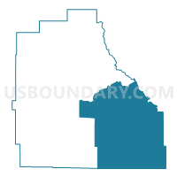
Outline

Summary
| Unique Area Identifier | 698867 |
| Name | BOULDER Voting District |
| County | Sublette County |
| State | Wyoming |
| Area (square miles) | 1,504.46 |
| Land Area (square miles) | 1,491.21 |
| Water Area (square miles) | 13.25 |
| % of Land Area | 99.12 |
| % of Water Area | 0.88 |
| Latitude of the Internal Point | 42.56947560 |
| Longtitude of the Internal Point | -109.45704630 |
Maps


Graphs
Select a template below for downloading or customizing gragh for BOULDER Voting District, Sublette County, Wyoming


Neighbors
Neighoring Voting District (by Name) Neighboring Voting District on the Map
- ATLANTIC CITY Voting District, Fremont County, WY
- BEEBE Voting District, Fremont County, WY
- BIG PINEY Voting District, Sublette County, WY
- FARSON Voting District, Sweetwater County, WY
- FORT WASHAKIE Voting District, Fremont County, WY
- Marbleton North Voting District, Sublette County, WY
- PINEDALE Voting District, Sublette County, WY
- PINEDALE-WEST Voting District, Sublette County, WY
- Superior Voting District, Sweetwater County, WY
Top 10 Neighboring County Subdivision (by Population) Neighboring County Subdivision on the Map
- Rock Springs North CCD, Sweetwater County, WY (28,199)
- Wind River CCD, Fremont County, WY (26,330)
- Green River North CCD, Sweetwater County, WY (11,120)
- Lander CCD, Fremont County, WY (11,019)
- Pinedale CCD, Sublette County, WY (6,892)
- Boulder CCD, Sublette County, WY (401)
Top 10 Neighboring Place (by Population) Neighboring Place on the Map
Top 10 Neighboring Unified School District (by Population) Neighboring Unified School District on the Map
- Sweetwater County School District 1, WY (30,043)
- Fremont County School District 1, WY (11,330)
- Sublette County School District 1, WY (6,932)
- Sublette County School District 9, WY (4,119)
- Fremont County School District 21, WY (2,190)
Top 10 Neighboring State Legislative District Lower Chamber (by Population) Neighboring State Legislative District Lower Chamber on the Map
- State House District 22, WY (12,218)
- State House District 20, WY (10,187)
- State House District 33, WY (9,942)
- State House District 48, WY (8,185)
Top 10 Neighboring State Legislative District Upper Chamber (by Population) Neighboring State Legislative District Upper Chamber on the Map
- State Senate District 16, WY (23,184)
- State Senate District 14, WY (19,890)
- State Senate District 25, WY (19,502)
- State Senate District 12, WY (17,585)
Top 10 Neighboring 111th Congressional District (by Population) Neighboring 111th Congressional District on the Map
Top 10 Neighboring Census Tract (by Population) Neighboring Census Tract on the Map
- Census Tract 1.02, Sublette County, WY (5,926)
- Census Tract 3, Fremont County, WY (4,422)
- Census Tract 1.01, Sublette County, WY (4,321)
- Census Tract 9401, Fremont County, WY (3,951)
- Census Tract 9716, Sweetwater County, WY (2,092)