


Shell Lake - C 2 Voting District, Washburn County, Wisconsin
About
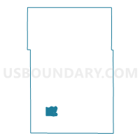
Outline

Summary
| Unique Area Identifier | 697550 |
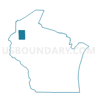
| Name | Shell Lake - C 2 Voting District |
| County | Washburn County |
| State | Wisconsin |
| Area (square miles) | 7.52 |
| Land Area (square miles) | 3.29 |
| Water Area (square miles) | 4.23 |
| % of Land Area | 43.79 |
| % of Water Area | 56.21 |
| Latitude of the Internal Point | 45.72637030 |
| Longtitude of the Internal Point | -91.91002500 |
Maps

Graphs
Select a template below for downloading or customizing gragh for Shell Lake - C 2 Voting District, Washburn County, Wisconsin


Neighbors
Neighoring Voting District (by Name) Neighboring Voting District on the Map
- BARRONETT - T 1 Voting District, Washburn County, WI
- BASHAW - T 1 Voting District, Washburn County, WI
- SARONA - T 1 Voting District, Washburn County, WI
- Shell Lake - C 1 Voting District, Washburn County, WI
Top 10 Neighboring County Subdivision (by Population) Neighboring County Subdivision on the Map
- Shell Lake city, Washburn County, WI (1,347)
- Bashaw town, Washburn County, WI (946)
- Barronett town, Washburn County, WI (442)
- Sarona town, Washburn County, WI (384)