


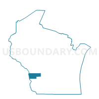
UNION - T 2 Voting District, Vernon County, Wisconsin
About
Outline

Summary
| Unique Area Identifier | 697332 |
| Name | UNION - T 2 Voting District |
| County | Vernon County |
| State | Wisconsin |
| Area (square miles) | 7.94 |
| Land Area (square miles) | 7.94 |
| Water Area (square miles) | 0.00 |
| % of Land Area | 99.99 |
| % of Water Area | 0.01 |
| Latitude of the Internal Point | 43.62254240 |
| Longtitude of the Internal Point | -90.53596900 |
Maps


Graphs
Select a template below for downloading or customizing gragh for UNION - T 2 Voting District, Vernon County, Wisconsin


Neighbors
Neighoring Voting District (by Name) Neighboring Voting District on the Map
- FOREST - T 1 Voting District, Vernon County, WI
- STARK - T 1 Voting District, Vernon County, WI
- STARK - T 2 Voting District, Vernon County, WI
- UNION - T 1 Voting District, Vernon County, WI
Top 10 Neighboring County Subdivision (by Population) Neighboring County Subdivision on the Map
- Union town, Vernon County, WI (700)
- Forest town, Vernon County, WI (634)
- Stark town, Vernon County, WI (363)
Top 10 Neighboring Unified School District (by Population) Neighboring Unified School District on the Map
- Hillsboro School District, WI (4,359)
- Kickapoo Area School District, WI (3,091)
- La Farge School District, WI (1,838)