


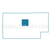
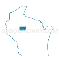
MOLITOR - T 1 Voting District, Taylor County, Wisconsin
About
Outline

Summary
| Unique Area Identifier | 697199 |
| Name | MOLITOR - T 1 Voting District |
| County | Taylor County |
| State | Wisconsin |
| Area (square miles) | 35.94 |
| Land Area (square miles) | 35.29 |
| Water Area (square miles) | 0.65 |
| % of Land Area | 98.20 |
| % of Water Area | 1.80 |
| Latitude of the Internal Point | 45.25231240 |
| Longtitude of the Internal Point | -90.50829460 |
Maps

Graphs
Select a template below for downloading or customizing gragh for MOLITOR - T 1 Voting District, Taylor County, Wisconsin


Neighbors
Neighoring Voting District (by Name) Neighboring Voting District on the Map
- CHELSEA - T 1 Voting District, Taylor County, WI
- GROVER - T 1 Voting District, Taylor County, WI
- HAMMEL - T 1 Voting District, Taylor County, WI
- HAMMEL - T 2 Voting District, Taylor County, WI
- MEDFORD - T 1 Voting District, Taylor County, WI
- WESTBORO - T 1 Voting District, Taylor County, WI
Top 10 Neighboring County Subdivision (by Population) Neighboring County Subdivision on the Map
- Medford town, Taylor County, WI (2,606)
- Chelsea town, Taylor County, WI (806)
- Hammel town, Taylor County, WI (713)
- Westboro town, Taylor County, WI (684)
- Molitor town, Taylor County, WI (324)
- Grover town, Taylor County, WI (256)
Top 10 Neighboring Unified School District (by Population) Neighboring Unified School District on the Map
- Medford Area School District, WI (14,380)
- Gilman School District, WI (3,213)
- Rib Lake School District, WI (2,673)