


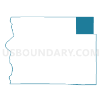
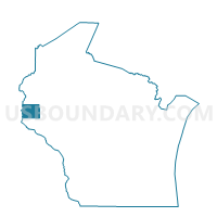
FOREST - T 1 Voting District, St. Croix County, Wisconsin
About
Outline

Summary
| Unique Area Identifier | 696834 |
| Name | FOREST - T 1 Voting District |
| County | St. Croix County |
| State | Wisconsin |
| Area (square miles) | 37.19 |
| Land Area (square miles) | 37.14 |
| Water Area (square miles) | 0.05 |
| % of Land Area | 99.86 |
| % of Water Area | 0.14 |
| Latitude of the Internal Point | 45.16042830 |
| Longtitude of the Internal Point | -92.22979280 |
Maps

Graphs
Select a template below for downloading or customizing gragh for FOREST - T 1 Voting District, St. Croix County, Wisconsin


Neighbors
Neighoring Voting District (by Name) Neighboring Voting District on the Map
- BLACK BROOK - T 1 Voting District, Polk County, WI
- CLEAR LAKE - T 1 Voting District, Polk County, WI
- CYLON - T 1 Voting District, St. Croix County, WI
- EMERALD - T 1 Voting District, St. Croix County, WI
- GLENWOOD - T 1 Voting District, St. Croix County, WI
- NEW HAVEN - T 1 Voting District, Dunn County, WI
- VANCE CREEK - T 1 Voting District, Barron County, WI
Top 10 Neighboring County Subdivision (by Population) Neighboring County Subdivision on the Map
- Black Brook town, Polk County, WI (1,325)
- Clear Lake town, Polk County, WI (899)
- Emerald town, St. Croix County, WI (853)
- Glenwood town, St. Croix County, WI (785)
- Cylon town, St. Croix County, WI (683)
- New Haven town, Dunn County, WI (677)
- Vance Creek town, Barron County, WI (669)
- Forest town, St. Croix County, WI (629)
Top 10 Neighboring Unified School District (by Population) Neighboring Unified School District on the Map
- New Richmond School District, WI (16,735)
- Boyceville Community School District, WI (4,531)
- Glenwood City School District, WI (4,058)
- Clear Lake School District, WI (3,452)
Top 10 Neighboring State Legislative District Lower Chamber (by Population) Neighboring State Legislative District Lower Chamber on the Map
- Assembly District 29, WI (66,814)
- Assembly District 28, WI (59,273)
- Assembly District 67, WI (58,722)
- Assembly District 75, WI (54,961)
Top 10 Neighboring State Legislative District Upper Chamber (by Population) Neighboring State Legislative District Upper Chamber on the Map
- State Senate District 10, WI (192,662)
- State Senate District 23, WI (176,958)
- State Senate District 25, WI (162,546)
Top 10 Neighboring 111th Congressional District (by Population) Neighboring 111th Congressional District on the Map
Top 10 Neighboring Census Tract (by Population) Neighboring Census Tract on the Map
- Census Tract 1208, St. Croix County, WI (8,341)
- Census Tract 1206, St. Croix County, WI (7,569)
- Census Tract 9, Barron County, WI (5,123)
- Census Tract 9610, Polk County, WI (4,766)
- Census Tract 9702, Dunn County, WI (4,737)
- Census Tract 1207, St. Croix County, WI (4,569)
- Census Tract 9611, Polk County, WI (3,907)
- Census Tract 9701, Dunn County, WI (3,879)