


STRICKLAND - T 1 Voting District, Rusk County, Wisconsin
About
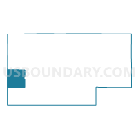
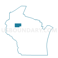
Outline

Summary
| Unique Area Identifier | 696741 |
| Name | STRICKLAND - T 1 Voting District |
| County | Rusk County |
| State | Wisconsin |
| Area (square miles) | 35.12 |
| Land Area (square miles) | 34.72 |
| Water Area (square miles) | 0.39 |
| % of Land Area | 98.88 |
| % of Water Area | 1.12 |
| Latitude of the Internal Point | 45.41494650 |
| Longtitude of the Internal Point | -91.48304870 |
Maps

Graphs
Select a template below for downloading or customizing gragh for STRICKLAND - T 1 Voting District, Rusk County, Wisconsin


Neighbors
Neighoring Voting District (by Name) Neighboring Voting District on the Map
- BIG BEND - T 1 Voting District, Rusk County, WI
- CHETEK - T 1 Voting District, Barron County, WI
- DOYLE - T 1 Voting District, Barron County, WI
- RUSK - T 1 Voting District, Rusk County, WI
- STUBBS - T 1 Voting District, Rusk County, WI
- SUMNER - T 2 Voting District, Barron County, WI
- Weyerhaeuser - V 1 Voting District, Rusk County, WI
- WILKINSON - T 1 Voting District, Rusk County, WI
Top 10 Neighboring County Subdivision (by Population) Neighboring County Subdivision on the Map
- Chetek town, Barron County, WI (1,644)
- Sumner town, Barron County, WI (798)
- Stubbs town, Rusk County, WI (579)
- Rusk town, Rusk County, WI (525)
- Doyle town, Barron County, WI (453)
- Big Bend town, Rusk County, WI (358)
- Strickland town, Rusk County, WI (280)
- Weyerhaeuser village, Rusk County, WI (238)
- Wilkinson town, Rusk County, WI (40)
Top 10 Neighboring Place (by Population) Neighboring Place on the Map
Top 10 Neighboring Unified School District (by Population) Neighboring Unified School District on the Map
- Chetek School District, WI (6,980)
- Cameron School District, WI (4,871)
- Weyerhaeuser Area School District, WI (1,157)
Top 10 Neighboring State Legislative District Lower Chamber (by Population) Neighboring State Legislative District Lower Chamber on the Map
Top 10 Neighboring State Legislative District Upper Chamber (by Population) Neighboring State Legislative District Upper Chamber on the Map
Top 10 Neighboring 111th Congressional District (by Population) Neighboring 111th Congressional District on the Map
Top 10 Neighboring Census Tract (by Population) Neighboring Census Tract on the Map
- Census Tract 10.02, Barron County, WI (5,572)
- Census Tract 8, Barron County, WI (5,435)
- Census Tract 9602, Rusk County, WI (2,028)