


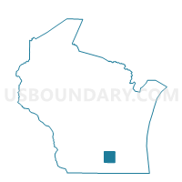
Waterloo - C 5 Voting District, Jefferson County, Wisconsin
About
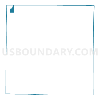
Outline

Summary
| Unique Area Identifier | 694163 |
| Name | Waterloo - C 5 Voting District |
| County | Jefferson County |
| State | Wisconsin |
| Area (square miles) | 1.32 |
| Land Area (square miles) | 1.31 |
| Water Area (square miles) | 0.01 |
| % of Land Area | 99.33 |
| % of Water Area | 0.67 |
| Latitude of the Internal Point | 43.17558370 |
| Longtitude of the Internal Point | -88.97951010 |
Maps

Graphs
Select a template below for downloading or customizing gragh for Waterloo - C 5 Voting District, Jefferson County, Wisconsin


Neighbors
Neighoring Voting District (by Name) Neighboring Voting District on the Map
- PORTLAND - T 1 Voting District, Dodge County, WI
- PORTLAND - T 2 Voting District, Dodge County, WI
- Waterloo - C 1 Voting District, Jefferson County, WI
- Waterloo - C 3 Voting District, Jefferson County, WI
- Waterloo - C 4 Voting District, Jefferson County, WI
- WATERLOO - T 1 Voting District, Jefferson County, WI
Top 10 Neighboring County Subdivision (by Population) Neighboring County Subdivision on the Map
- Waterloo city, Jefferson County, WI (3,333)
- Portland town, Dodge County, WI (1,079)
- Waterloo town, Jefferson County, WI (909)