


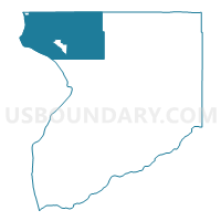
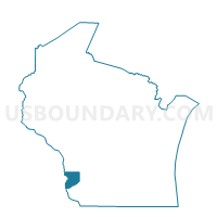
FREEMAN - T 1 Voting District, Crawford County, Wisconsin
About
Outline

Summary
| Unique Area Identifier | 692900 |
| Name | FREEMAN - T 1 Voting District |
| County | Crawford County |
| State | Wisconsin |
| Area (square miles) | 77.74 |
| Land Area (square miles) | 67.28 |
| Water Area (square miles) | 10.46 |
| % of Land Area | 86.55 |
| % of Water Area | 13.45 |
| Latitude of the Internal Point | 43.37407690 |
| Longtitude of the Internal Point | -91.07987330 |
Maps

Graphs
Select a template below for downloading or customizing gragh for FREEMAN - T 1 Voting District, Crawford County, Wisconsin


Neighbors
Neighoring Voting District (by Name) Neighboring Voting District on the Map
- De Solo - V 1 Voting District, Vernon County, WI
- De Soto - V 1 Voting District, Crawford County, WI
- Ferryville - V 1 Voting District, Crawford County, WI
- FRANKLIN - T 1 Voting District, Vernon County, WI
- LAFAYETTE TWP Voting District, Allamakee County, IA
- LANSING TWP Voting District, Allamakee County, IA
- SENECA - T 1 Voting District, Crawford County, WI
- STERLING - T 1 Voting District, Vernon County, WI
- UTICA - T 1 Voting District, Crawford County, WI
- WHEATLAND - T 1 Voting District, Vernon County, WI
Top 10 Neighboring County Subdivision (by Population) Neighboring County Subdivision on the Map
- Lansing township, Allamakee County, IA (1,424)
- Franklin town, Vernon County, WI (1,140)
- Seneca town, Crawford County, WI (866)
- Freeman town, Crawford County, WI (686)
- Utica town, Crawford County, WI (661)
- Sterling town, Vernon County, WI (633)
- Wheatland town, Vernon County, WI (561)
- Lafayette township, Allamakee County, IA (421)
- De Soto village, Vernon County, WI (179)
- Ferryville village, Crawford County, WI (176)
Top 10 Neighboring Place (by Population) Neighboring Place on the Map
Top 10 Neighboring Unified School District (by Population) Neighboring Unified School District on the Map
- Viroqua Area School District, WI (8,693)
- De Soto Area School District, WI (4,375)
- North Crawford School District, WI (3,095)
- Eastern Allamakee Community School District, IA (2,730)
- Seneca School District, WI (1,569)
Top 10 Neighboring State Legislative District Lower Chamber (by Population) Neighboring State Legislative District Lower Chamber on the Map
Top 10 Neighboring State Legislative District Upper Chamber (by Population) Neighboring State Legislative District Upper Chamber on the Map
Top 10 Neighboring 111th Congressional District (by Population) Neighboring 111th Congressional District on the Map
Top 10 Neighboring Census Tract (by Population) Neighboring Census Tract on the Map
- Census Tract 9607, Vernon County, WI (4,017)
- Census Tract 9605, Vernon County, WI (3,507)
- Census Tract 9602, Crawford County, WI (2,291)
- Census Tract 9601, Allamakee County, IA (2,130)
Top 10 Neighboring 5-Digit ZIP Code Tabulation Area (by Population) Neighboring 5-Digit ZIP Code Tabulation Area on the Map
- 54665, WI (8,427)
- 52151, IA (2,138)
- 54631, WI (1,844)
- 54624, WI (1,383)
- 54626, WI (1,215)
- 54628, WI (1,092)