


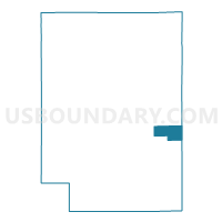
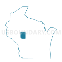
FREMONT - T 2 Voting District, Clark County, Wisconsin
About
Outline

Summary
| Unique Area Identifier | 692795 |
| Name | FREMONT - T 2 Voting District |
| County | Clark County |
| State | Wisconsin |
| Area (square miles) | 14.80 |
| Land Area (square miles) | 14.77 |
| Water Area (square miles) | 0.03 |
| % of Land Area | 99.81 |
| % of Water Area | 0.19 |
| Latitude of the Internal Point | 44.66374100 |
| Longtitude of the Internal Point | -90.36970110 |
Maps

Graphs
Select a template below for downloading or customizing gragh for FREMONT - T 2 Voting District, Clark County, Wisconsin


Neighbors
Neighoring Voting District (by Name) Neighboring Voting District on the Map
- FREMONT - T 1 Voting District, Clark County, WI
- LINCOLN - T 1 Voting District, Wood County, WI
- LINCOLN - T 2 Voting District, Wood County, WI
- LOYAL - T 2 Voting District, Clark County, WI
- SHERMAN - T 1 Voting District, Clark County, WI
- SPENCER - T 2 Voting District, Marathon County, WI
- YORK - T 1 Voting District, Clark County, WI
Top 10 Neighboring County Subdivision (by Population) Neighboring County Subdivision on the Map
- Spencer town, Marathon County, WI (1,581)
- Lincoln town, Wood County, WI (1,564)
- Fremont town, Clark County, WI (1,265)
- York town, Clark County, WI (886)
- Sherman town, Clark County, WI (882)
- Loyal town, Clark County, WI (826)
Top 10 Neighboring Place (by Population) Neighboring Place on the Map
Top 10 Neighboring Unified School District (by Population) Neighboring Unified School District on the Map
- Marshfield School District, WI (27,858)
- Spencer School District, WI (4,519)
- Loyal School District, WI (4,037)
- Granton Area School District, WI (2,139)
Top 10 Neighboring State Legislative District Lower Chamber (by Population) Neighboring State Legislative District Lower Chamber on the Map
Top 10 Neighboring State Legislative District Upper Chamber (by Population) Neighboring State Legislative District Upper Chamber on the Map
Top 10 Neighboring 111th Congressional District (by Population) Neighboring 111th Congressional District on the Map
Top 10 Neighboring Census Tract (by Population) Neighboring Census Tract on the Map
- Census Tract 21, Marathon County, WI (7,190)
- Census Tract 9505, Clark County, WI (5,277)
- Census Tract 107, Wood County, WI (5,076)
- Census Tract 9506, Clark County, WI (4,797)