


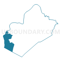
Voting District 82, Wood County, West Virginia
About
Outline

Summary
| Unique Area Identifier | 692063 |
| Name | Voting District 82 |
| County | Wood County |
| State | West Virginia |
| Area (square miles) | 31.97 |
| Land Area (square miles) | 29.90 |
| Water Area (square miles) | 2.07 |
| % of Land Area | 93.51 |
| % of Water Area | 6.49 |
| Latitude of the Internal Point | 39.14042420 |
| Longtitude of the Internal Point | -81.71064540 |
Maps

Graphs
Select a template below for downloading or customizing gragh for Voting District 82, Wood County, West Virginia


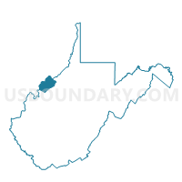
Neighbors
Neighoring Voting District (by Name) Neighboring Voting District on the Map
- Voting District 1, Jackson County, WV
- Voting District 5, Jackson County, WV
- Voting District 62A, Wood County, WV
- Voting District 81, Wood County, WV
- Voting District 84, Wood County, WV
- LITTLE HOCKING SOUTH Voting District, Washington County, OH
- SOUTH OLIVE Voting District, Meigs County, OH
- Voting District TROY EAST, Athens County, OH
- Voting District TROY WEST, Athens County, OH
Top 10 Neighboring County Subdivision (by Population) Neighboring County Subdivision on the Map
- Northern district, Jackson County, WV (8,753)
- Belpre township, Washington County, OH (3,869)
- Troy township, Athens County, OH (2,617)
- Harris district, Wood County, WV (1,820)
- Olive township, Meigs County, OH (1,798)
- Steele district, Wood County, WV (1,373)
Top 10 Neighboring Place (by Population) Neighboring Place on the Map
Top 10 Neighboring Unified School District (by Population) Neighboring Unified School District on the Map
- Wood County School District, WV (86,956)
- Jackson County School District, WV (29,211)
- Warren Local School District, OH (14,351)
- Federal Hocking Local School District, OH (8,100)
- Eastern Local School District, OH (5,180)
Top 10 Neighboring State Legislative District Lower Chamber (by Population) Neighboring State Legislative District Lower Chamber on the Map
- State House District 92, OH (123,037)
- State House District 10, WV (55,234)
- State House District 12, WV (20,112)
- State House District 9, WV (19,202)
Top 10 Neighboring State Legislative District Upper Chamber (by Population) Neighboring State Legislative District Upper Chamber on the Map
- State Senate District 20, OH (357,708)
- State Senate District 4, WV (117,998)
- State Senate District 3, WV (109,227)
Top 10 Neighboring 111th Congressional District (by Population) Neighboring 111th Congressional District on the Map
- Congressional District 2, WV (648,186)
- Congressional District 6, OH (623,742)
- Congressional District 1, WV (615,991)
Top 10 Neighboring Census Tract (by Population) Neighboring Census Tract on the Map
- Census Tract 202, Washington County, OH (6,942)
- Census Tract 9632, Jackson County, WV (4,620)
- Census Tract 9641, Meigs County, OH (4,209)
- Census Tract 9736, Athens County, OH (3,972)
- Census Tract 108, Wood County, WV (3,153)
Top 10 Neighboring 5-Digit ZIP Code Tabulation Area (by Population) Neighboring 5-Digit ZIP Code Tabulation Area on the Map
- 26164, WV (8,262)
- 26181, WV (6,127)
- 45723, OH (3,740)
- 45742, OH (3,014)
- 45772, OH (2,149)
- 26133, WV (1,415)