


Voting District 146, Ohio County, West Virginia
About
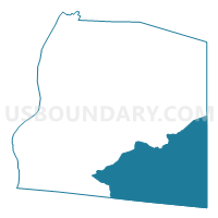
Outline

Summary
| Unique Area Identifier | 691650 |
| Name | Voting District 146 |
| County | Ohio County |
| State | West Virginia |
| Area (square miles) | 22.24 |
| Land Area (square miles) | 22.15 |
| Water Area (square miles) | 0.10 |
| % of Land Area | 99.56 |
| % of Water Area | 0.44 |
| Latitude of the Internal Point | 40.05655480 |
| Longtitude of the Internal Point | -80.56751870 |
Maps


Graphs
Select a template below for downloading or customizing gragh for Voting District 146, Ohio County, West Virginia


Neighbors
Neighoring Voting District (by Name) Neighboring Voting District on the Map
- Voting District 131, Ohio County, WV
- Voting District 137, Ohio County, WV
- Voting District 141, Ohio County, WV
- Voting District 143, Ohio County, WV
- Voting District 161, Ohio County, WV
- Voting District 38, Marshall County, WV
- Voting District 39, Marshall County, WV
- DONEGAL TWP VTD 01, Washington County, PA
- WEST FINLEY TWP VTD 01, Washington County, PA
- WEST FINLEY TWP VTD 02, Washington County, PA
Top 10 Neighboring County Subdivision (by Population) Neighboring County Subdivision on the Map
- District 1, Ohio County, WV (16,752)
- District 3, Ohio County, WV (15,243)
- District 1, Marshall County, WV (10,892)
- Donegal township, Washington County, PA (2,465)
- West Finley township, Washington County, PA (878)
Top 10 Neighboring Place (by Population) Neighboring Place on the Map
Top 10 Neighboring Unified School District (by Population) Neighboring Unified School District on the Map
- Ohio County School District, WV (44,443)
- Marshall County School District, WV (33,107)
- McGuffey School District, PA (12,757)
Top 10 Neighboring State Legislative District Lower Chamber (by Population) Neighboring State Legislative District Lower Chamber on the Map
- State House District 49, PA (58,268)
- State House District 2, WV (34,538)
- State House District 4, WV (33,317)
- State House District 3, WV (31,628)
Top 10 Neighboring State Legislative District Upper Chamber (by Population) Neighboring State Legislative District Upper Chamber on the Map
- State Senate District 46, PA (235,908)
- State Senate District 2, WV (101,327)
- State Senate District 1, WV (95,975)
Top 10 Neighboring 111th Congressional District (by Population) Neighboring 111th Congressional District on the Map
Top 10 Neighboring Census Tract (by Population) Neighboring Census Tract on the Map
- Census Tract 7310, Washington County, PA (6,053)
- Census Tract 18, Ohio County, WV (5,261)
- Census Tract 208, Marshall County, WV (4,741)
- Census Tract 21, Ohio County, WV (4,346)
- Census Tract 7960, Washington County, PA (3,375)
- Census Tract 22, Ohio County, WV (2,823)