


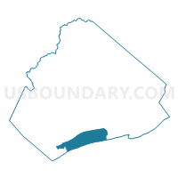
Voting District 1, Mercer County, West Virginia
About
Outline

Summary
| Unique Area Identifier | 691400 |
| Name | Voting District 1 |
| County | Mercer County |
| State | West Virginia |
| Area (square miles) | 15.43 |
| Land Area (square miles) | 15.39 |
| Water Area (square miles) | 0.04 |
| % of Land Area | 99.74 |
| % of Water Area | 0.26 |
| Latitude of the Internal Point | 37.29045950 |
| Longtitude of the Internal Point | -81.11447850 |
Maps

Graphs
Select a template below for downloading or customizing gragh for Voting District 1, Mercer County, West Virginia


Neighbors
Neighoring Voting District (by Name) Neighboring Voting District on the Map
- Voting District 15, Mercer County, WV
- Voting District 20, Mercer County, WV
- Voting District 34, Mercer County, WV
- Voting District 36, Mercer County, WV
- Voting District 38, Mercer County, WV
- Voting District 44, Mercer County, WV
- Voting District 79, Mercer County, WV
- Voting District 98, Mercer County, WV
- Rocky Gap Voting District, Bland County, VA
Top 10 Neighboring County Subdivision (by Population) Neighboring County Subdivision on the Map
- District III, Mercer County, WV (21,345)
- District I, Mercer County, WV (18,572)
- District 4, Bland County, VA (1,569)
Top 10 Neighboring Place (by Population) Neighboring Place on the Map
Top 10 Neighboring Unified School District (by Population) Neighboring Unified School District on the Map
Top 10 Neighboring State Legislative District Lower Chamber (by Population) Neighboring State Legislative District Lower Chamber on the Map
- State House District 6, VA (73,250)
- State House District 25, WV (39,163)
- State House District 24, WV (17,083)
Top 10 Neighboring State Legislative District Upper Chamber (by Population) Neighboring State Legislative District Upper Chamber on the Map
- State Senate District 38, VA (175,805)
- State Senate District 10, WV (106,143)
- State Senate District 6, WV (93,502)
Top 10 Neighboring 111th Congressional District (by Population) Neighboring 111th Congressional District on the Map
Top 10 Neighboring Census Tract (by Population) Neighboring Census Tract on the Map
- Census Tract 23, Mercer County, WV (4,929)
- Census Tract 22, Mercer County, WV (4,649)
- Census Tract 401, Bland County, VA (3,901)
- Census Tract 402, Bland County, VA (2,923)
- Census Tract 24, Mercer County, WV (2,895)
- Census Tract 19, Mercer County, WV (1,857)