


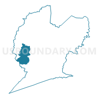
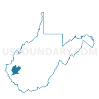
Voting District 23, Lincoln County, West Virginia
About
Outline

Summary
| Unique Area Identifier | 691083 |
| Name | Voting District 23 |
| County | Lincoln County |
| State | West Virginia |
| Area (square miles) | 19.70 |
| Land Area (square miles) | 19.57 |
| Water Area (square miles) | 0.13 |
| % of Land Area | 99.35 |
| % of Water Area | 0.65 |
| Latitude of the Internal Point | 38.12466150 |
| Longtitude of the Internal Point | -82.21103790 |
Maps

Graphs
Select a template below for downloading or customizing gragh for Voting District 23, Lincoln County, West Virginia


Neighbors
Neighoring Voting District (by Name) Neighboring Voting District on the Map
- Voting District 20, Lincoln County, WV
- Voting District 21, Lincoln County, WV
- Voting District 22, Lincoln County, WV
- Voting District 26, Lincoln County, WV
- Voting District 28, Lincoln County, WV
- Voting District 41, Wayne County, WV
Top 10 Neighboring County Subdivision (by Population) Neighboring County Subdivision on the Map
- Stonewall district, Wayne County, WV (8,100)
- Harts Creek district, Lincoln County, WV (3,862)
- Laurel Hill district, Lincoln County, WV (2,125)
Top 10 Neighboring Unified School District (by Population) Neighboring Unified School District on the Map
Top 10 Neighboring State Legislative District Lower Chamber (by Population) Neighboring State Legislative District Lower Chamber on the Map
Top 10 Neighboring State Legislative District Upper Chamber (by Population) Neighboring State Legislative District Upper Chamber on the Map
Top 10 Neighboring 111th Congressional District (by Population) Neighboring 111th Congressional District on the Map
Top 10 Neighboring Census Tract (by Population) Neighboring Census Tract on the Map
- Census Tract 9556, Lincoln County, WV (4,682)
- Census Tract 9558, Lincoln County, WV (3,653)
- Census Tract 9557, Lincoln County, WV (3,536)
- Census Tract 210, Wayne County, WV (3,398)
- Census Tract 209, Wayne County, WV (3,052)