


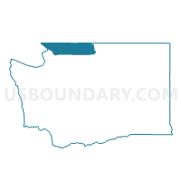
Ferndale 501 Voting District, Whatcom County, Washington
About
Outline

Summary
| Unique Area Identifier | 690095 |
| Name | Ferndale 501 Voting District |
| County | Whatcom County |
| State | Washington |
| Area (square miles) | 0.39 |
| Land Area (square miles) | 0.39 |
| Water Area (square miles) | 0.00 |
| % of Land Area | 100.00 |
| % of Water Area | 0.00 |
| Latitude of the Internal Point | 48.86582130 |
| Longtitude of the Internal Point | -122.61453800 |
Maps

Graphs
Select a template below for downloading or customizing gragh for Ferndale 501 Voting District, Whatcom County, Washington


Neighbors
Neighoring Voting District (by Name) Neighboring Voting District on the Map
- Voting District 110, Whatcom County, WA
- Voting District 111, Whatcom County, WA
- Ferndale 502 Voting District, Whatcom County, WA
- Ferndale 503 Voting District, Whatcom County, WA
- Ferndale 504 Voting District, Whatcom County, WA