


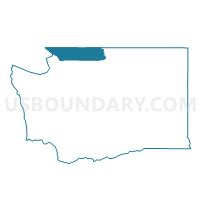
Voting District 138, Whatcom County, Washington
About
Outline

Summary
| Unique Area Identifier | 689977 |
| Name | Voting District 138 |
| County | Whatcom County |
| State | Washington |
| Area (square miles) | 56.39 |
| Land Area (square miles) | 55.80 |
| Water Area (square miles) | 0.59 |
| % of Land Area | 98.95 |
| % of Water Area | 1.05 |
| Latitude of the Internal Point | 48.85493000 |
| Longtitude of the Internal Point | -122.11882820 |
Maps

Graphs
Select a template below for downloading or customizing gragh for Voting District 138, Whatcom County, Washington


Neighbors
Neighoring Voting District (by Name) Neighboring Voting District on the Map
- Voting District 134, Whatcom County, WA
- Voting District 135, Whatcom County, WA
- Voting District 136, Whatcom County, WA
- Voting District 137, Whatcom County, WA
- Voting District 143, Whatcom County, WA
- Voting District 144, Whatcom County, WA
- Voting District 145, Whatcom County, WA
- Mount Baker National Forest Leg 42, Whatcom County, WA
Top 10 Neighboring County Subdivision (by Population) Neighboring County Subdivision on the Map
Top 10 Neighboring Place (by Population) Neighboring Place on the Map
- Peaceful Valley CDP, WA (3,324)
- Deming CDP, WA (353)
- Maple Falls CDP, WA (324)
- Kendall CDP, WA (191)