


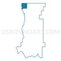
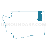
Rockcut Voting District, Stevens County, Washington
About
Outline
Summary
| Unique Area Identifier | 689547 |
| Name | Rockcut Voting District |
| County | Stevens County |
| State | Washington |
| Area (square miles) | 63.07 |
| Land Area (square miles) | 62.92 |
| Water Area (square miles) | 0.15 |
| % of Land Area | 99.76 |
| % of Water Area | 0.24 |
| Latitude of the Internal Point | 48.95351900 |
| Longtitude of the Internal Point | -118.10821680 |
Maps

Graphs
Select a template below for downloading or customizing gragh for Rockcut Voting District, Stevens County, Washington


Neighbors
Neighoring Voting District (by Name) Neighboring Voting District on the Map
- Columbia Voting District, Stevens County, WA
- First Thought Voting District, Stevens County, WA
- Orient Voting District, Ferry County, WA