


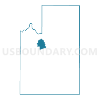
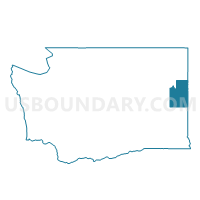
Voting District 6026, Spokane County, Washington
About
Outline

Summary
| Unique Area Identifier | 689397 |
| Name | Voting District 6026 |
| County | Spokane County |
| State | Washington |
| Area (square miles) | 19.88 |
| Land Area (square miles) | 19.77 |
| Water Area (square miles) | 0.11 |
| % of Land Area | 99.46 |
| % of Water Area | 0.54 |
| Latitude of the Internal Point | 47.71337330 |
| Longtitude of the Internal Point | -117.54906240 |
Maps

Graphs
Select a template below for downloading or customizing gragh for Voting District 6026, Spokane County, Washington


Neighbors
Neighoring Voting District (by Name) Neighboring Voting District on the Map
- Voting District 6010, Spokane County, WA
- Voting District 6024, Spokane County, WA
- Voting District 6025, Spokane County, WA
- Voting District 6108, Spokane County, WA
- Voting District 6118, Spokane County, WA
- Voting District 6126, Spokane County, WA
- Voting District 7006, Spokane County, WA
- Voting District 7007, Spokane County, WA
- Voting District 7008, Spokane County, WA
- Voting District 7100, Spokane County, WA
Top 10 Neighboring County Subdivision (by Population) Neighboring County Subdivision on the Map
Top 10 Neighboring Place (by Population) Neighboring Place on the Map
Top 10 Neighboring Unified School District (by Population) Neighboring Unified School District on the Map
- Spokane Public Schools, WA (221,110)
- Cheney School District, WA (33,075)
- Nine Mile Falls School District, WA (8,720)
- Reardan-Edwall School District, WA (4,260)
- Great Northern School District, WA (695)
Top 10 Neighboring State Legislative District Lower Chamber (by Population) Neighboring State Legislative District Lower Chamber on the Map
Top 10 Neighboring State Legislative District Upper Chamber (by Population) Neighboring State Legislative District Upper Chamber on the Map
Top 10 Neighboring 111th Congressional District (by Population) Neighboring 111th Congressional District on the Map
Top 10 Neighboring Census Tract (by Population) Neighboring Census Tract on the Map
- Census Tract 104.02, Spokane County, WA (6,937)
- Census Tract 104.01, Spokane County, WA (6,246)
- Census Tract 106.01, Spokane County, WA (3,490)
- Census Tract 137, Spokane County, WA (3,076)