


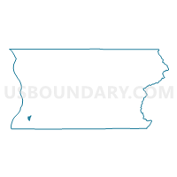
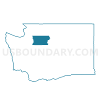
Ash Voting District, Snohomish County, Washington
About
Outline

Summary
| Unique Area Identifier | 688854 |
| Name | Ash Voting District |
| County | Snohomish County |
| State | Washington |
| Area (square miles) | 1.23 |
| Land Area (square miles) | 1.23 |
| Water Area (square miles) | 0.00 |
| % of Land Area | 100.00 |
| % of Water Area | 0.00 |
| Latitude of the Internal Point | 47.84808670 |
| Longtitude of the Internal Point | -122.26445340 |
Maps

Graphs
Select a template below for downloading or customizing gragh for Ash Voting District, Snohomish County, Washington


Neighbors
Neighoring Voting District (by Name) Neighboring Voting District on the Map
- Alder Voting District, Snohomish County, WA
- Butternut Voting District, Snohomish County, WA
- Dale Voting District, Snohomish County, WA
- Keeler Voting District, Snohomish County, WA
- Madison Voting District, Snohomish County, WA
- Magnolia Voting District, Snohomish County, WA
- Manordale Voting District, Snohomish County, WA
- Martha Lake Voting District, Snohomish County, WA
- Meadowcrest Voting District, Snohomish County, WA
- Royal Voting District, Snohomish County, WA
- Stone Gate Voting District, Snohomish County, WA
Top 10 Neighboring County Subdivision (by Population) Neighboring County Subdivision on the Map
Top 10 Neighboring Place (by Population) Neighboring Place on the Map
- North Lynnwood CDP, WA (16,574)
- Martha Lake CDP, WA (15,473)
- Alderwood Manor CDP, WA (8,442)
- Lake Stickney CDP, WA (7,777)
- Larch Way CDP, WA (3,318)
Top 10 Neighboring Unified School District (by Population) Neighboring Unified School District on the Map
Top 10 Neighboring State Legislative District Lower Chamber (by Population) Neighboring State Legislative District Lower Chamber on the Map
Top 10 Neighboring State Legislative District Upper Chamber (by Population) Neighboring State Legislative District Upper Chamber on the Map
Top 10 Neighboring 111th Congressional District (by Population) Neighboring 111th Congressional District on the Map
Top 10 Neighboring Census Tract (by Population) Neighboring Census Tract on the Map
- Census Tract 519.05, Snohomish County, WA (8,009)
- Census Tract 418.11, Snohomish County, WA (6,403)
- Census Tract 518.03, Snohomish County, WA (5,636)
- Census Tract 518.02, Snohomish County, WA (5,176)
- Census Tract 417.03, Snohomish County, WA (5,039)
- Census Tract 519.28, Snohomish County, WA (4,783)
- Census Tract 519.27, Snohomish County, WA (4,714)
- Census Tract 518.04, Snohomish County, WA (3,748)