


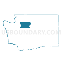
Sauk Voting District, Snohomish County, Washington
About
Outline

Summary
| Unique Area Identifier | 688676 |
| Name | Sauk Voting District |
| County | Snohomish County |
| State | Washington |
| Area (square miles) | 494.28 |
| Land Area (square miles) | 492.28 |
| Water Area (square miles) | 1.99 |
| % of Land Area | 99.60 |
| % of Water Area | 0.40 |
| Latitude of the Internal Point | 48.19166600 |
| Longtitude of the Internal Point | -121.20882210 |
Maps

Graphs
Select a template below for downloading or customizing gragh for Sauk Voting District, Snohomish County, Washington


Neighbors
Neighoring Voting District (by Name) Neighboring Voting District on the Map
- Voting District 116, Chelan County, WA
- Voting District 173, Chelan County, WA
- Voting District 190, Chelan County, WA
- Darrington Voting District, Snohomish County, WA
- Hazel Voting District, Snohomish County, WA
- Mansford Voting District, Skagit County, WA
- Robe Voting District, Snohomish County, WA
- Skagit County, Skagit County, WA
- Spada Voting District, Snohomish County, WA
Top 10 Neighboring County Subdivision (by Population) Neighboring County Subdivision on the Map
- Sultan CCD, Snohomish County, WA (14,286)
- Granite Falls CCD, Snohomish County, WA (13,608)
- Leavenworth-Lake Wenatchee CCD, Chelan County, WA (6,251)
- East Skagit CCD, Skagit County, WA (4,715)
- Darrington CCD, Snohomish County, WA (3,065)
- Lake Cavanaugh CCD, Skagit County, WA (2,989)
- Stehekin CCD, Chelan County, WA (152)
Top 10 Neighboring Place (by Population) Neighboring Place on the Map
Top 10 Neighboring Unified School District (by Population) Neighboring Unified School District on the Map
- Granite Falls School District, WA (13,285)
- Cascade School District, WA (9,560)
- Lake Chelan School District, WA (7,135)
- Concrete School District, WA (4,840)
- Darrington School District, WA (3,210)
- Stehekin School District, WA (104)
Top 10 Neighboring State Legislative District Lower Chamber (by Population) Neighboring State Legislative District Lower Chamber on the Map
Top 10 Neighboring State Legislative District Upper Chamber (by Population) Neighboring State Legislative District Upper Chamber on the Map
Top 10 Neighboring 111th Congressional District (by Population) Neighboring 111th Congressional District on the Map
Top 10 Neighboring Census Tract (by Population) Neighboring Census Tract on the Map
- Census Tract 9602, Chelan County, WA (6,251)
- Census Tract 536.02, Snohomish County, WA (5,640)
- Census Tract 9511, Skagit County, WA (4,715)
- Census Tract 538.01, Snohomish County, WA (3,639)
- Census Tract 537, Snohomish County, WA (3,065)
- Census Tract 9512, Skagit County, WA (2,989)
- Census Tract 9601, Chelan County, WA (2,369)
Top 10 Neighboring 5-Digit ZIP Code Tabulation Area (by Population) Neighboring 5-Digit ZIP Code Tabulation Area on the Map
- 98223, WA (40,815)
- 98252, WA (8,777)
- 98826, WA (6,504)
- 98816, WA (6,394)
- 98241, WA (2,129)
- 98267, WA (534)