


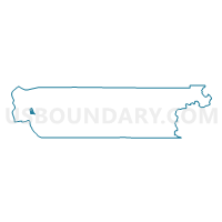
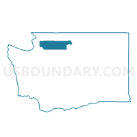
March Point Voting District, Skagit County, Washington
About
Outline

Summary
| Unique Area Identifier | 688395 |
| Name | March Point Voting District |
| County | Skagit County |
| State | Washington |
| Area (square miles) | 3.11 |
| Land Area (square miles) | 3.06 |
| Water Area (square miles) | 0.04 |
| % of Land Area | 98.58 |
| % of Water Area | 1.42 |
| Latitude of the Internal Point | 48.48237300 |
| Longtitude of the Internal Point | -122.55364590 |
Maps

Graphs
Select a template below for downloading or customizing gragh for March Point Voting District, Skagit County, Washington


Neighbors
Neighoring Voting District (by Name) Neighboring Voting District on the Map
- Anacortes 5 Voting District, Skagit County, WA
- Anacortes 6 Voting District, Skagit County, WA
- Dewey Voting District, Skagit County, WA
- Fildalgo Bay, Skagit County, WA
- Guemes Voting District, Skagit County, WA
- Padilla Voting District, Skagit County, WA
- Padilla Bay, Skagit County, WA
- Swinomish Voting District, Skagit County, WA
Top 10 Neighboring County Subdivision (by Population) Neighboring County Subdivision on the Map
Top 10 Neighboring Place (by Population) Neighboring Place on the Map
Top 10 Neighboring Unified School District (by Population) Neighboring Unified School District on the Map
Top 10 Neighboring State Legislative District Lower Chamber (by Population) Neighboring State Legislative District Lower Chamber on the Map
Top 10 Neighboring State Legislative District Upper Chamber (by Population) Neighboring State Legislative District Upper Chamber on the Map
Top 10 Neighboring 111th Congressional District (by Population) Neighboring 111th Congressional District on the Map
Top 10 Neighboring Census Tract (by Population) Neighboring Census Tract on the Map
- Census Tract 9408, Skagit County, WA (3,010)
- Census Tract 9501, Skagit County, WA (873)
- Census Tract 9901, Skagit County, WA (0)