


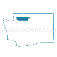
Fruitdale Voting District, Skagit County, Washington
About
Outline

Summary
| Unique Area Identifier | 688317 |
| Name | Fruitdale Voting District |
| County | Skagit County |
| State | Washington |
| Area (square miles) | 4.01 |
| Land Area (square miles) | 3.99 |
| Water Area (square miles) | 0.02 |
| % of Land Area | 99.59 |
| % of Water Area | 0.41 |
| Latitude of the Internal Point | 48.53207850 |
| Longtitude of the Internal Point | -122.22283640 |
Maps


Graphs
Select a template below for downloading or customizing gragh for Fruitdale Voting District, Skagit County, Washington


Neighbors
Neighoring Voting District (by Name) Neighboring Voting District on the Map
- Mcrae Voting District, Skagit County, WA
- Prairie Voting District, Skagit County, WA
- Samish Voting District, Skagit County, WA
- Sedro-Woolley 1 Voting District, Skagit County, WA
- Sedro-Woolley 2 Voting District, Skagit County, WA
- Sedro-Woolley 3 Voting District, Skagit County, WA
- Sedro-Woolley 5 Voting District, Skagit County, WA
- Sedro-Woolley 6 Voting District, Skagit County, WA
- Sedro-Woolley 7 Voting District, Skagit County, WA
- Van Fleet Voting District, Skagit County, WA