


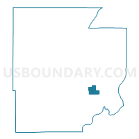
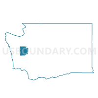
Oakland Voting District, Mason County, Washington
About
Outline

Summary
| Unique Area Identifier | 687571 |
| Name | Oakland Voting District |
| County | Mason County |
| State | Washington |
| Area (square miles) | 5.59 |
| Land Area (square miles) | 5.07 |
| Water Area (square miles) | 0.52 |
| % of Land Area | 90.74 |
| % of Water Area | 9.26 |
| Latitude of the Internal Point | 47.25508080 |
| Longtitude of the Internal Point | -123.01046910 |
Maps

Graphs
Select a template below for downloading or customizing gragh for Oakland Voting District, Mason County, Washington


Neighbors
Neighoring Voting District (by Name) Neighboring Voting District on the Map
- Bayshore Voting District, Mason County, WA
- Miller Voting District, Mason County, WA
- Pickering Voting District, Mason County, WA
- Timberlake Voting District, Mason County, WA
Top 10 Neighboring County Subdivision (by Population) Neighboring County Subdivision on the Map
- Union-Grapeview CCD, Mason County, WA (13,303)
- Timber Lake-Harstine Island CCD, Mason County, WA (7,343)