


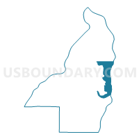
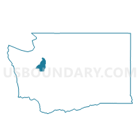
Water: Bainbridge Island, Kitsap County, Washington
About
Outline

Summary
| Unique Area Identifier | 687327 |
| Name | Water: Bainbridge Island |
| County | Kitsap County |
| State | Washington |
| Area (square miles) | 26.19 |
| Land Area (square miles) | 0.00 |
| Water Area (square miles) | 26.19 |
| % of Land Area | 0.00 |
| % of Water Area | 100.00 |
| Latitude of the Internal Point | 47.65488300 |
| Longtitude of the Internal Point | -122.47990760 |
Maps

Graphs
Select a template below for downloading or customizing gragh for Water: Bainbridge Island, Kitsap County, Washington


Neighbors
Neighoring Voting District (by Name) Neighboring Voting District on the Map
- Blakely Voting District, Kitsap County, WA
- Ferncliff Voting District, Kitsap County, WA
- Fort Ward Voting District, Kitsap County, WA
- Liberty Voting District, Kitsap County, WA
- Lighthouse Point Voting District, Kitsap County, WA
- Manchester Voting District, Kitsap County, WA
- Port Madison Voting District, Kitsap County, WA
- Rolling Bay Voting District, Kitsap County, WA
- Seabold Voting District, Kitsap County, WA
- Skiff Point Voting District, Kitsap County, WA
- Torvanger Voting District, Kitsap County, WA
- Totten Voting District, Kitsap County, WA
- Water: Port Madison, Kitsap County, WA
- Water: Puget Sound - Seattle Leg 34, King County, WA
- Water: Puget Sound - Seattle Leg 36 Con 1, King County, WA
- Water: Puget Sound - Seattle Leg 36 Con 7, King County, WA
- Water: Puget Sound Leg 23, Kitsap County, WA
- Water: Puget Sound Leg 26, Kitsap County, WA
- Wing Point Voting District, Kitsap County, WA
Top 10 Neighboring County Subdivision (by Population) Neighboring County Subdivision on the Map
- Seattle CCD, King County, WA (965,769)
- Port Orchard CCD, Kitsap County, WA (67,580)
- Poulsbo CCD, Kitsap County, WA (43,309)
- Bainbridge Island CCD, Kitsap County, WA (23,025)
- Kingston CCD, Kitsap County, WA (11,392)
Top 10 Neighboring Place (by Population) Neighboring Place on the Map
- Seattle city, WA (608,660)
- Bainbridge Island city, WA (23,025)
- Manchester CDP, WA (5,413)
- Suquamish CDP, WA (4,140)
Top 10 Neighboring Unified School District (by Population) Neighboring Unified School District on the Map
- Seattle School District, WA (609,471)
- South Kitsap School District, WA (68,017)
- North Kitsap School District, WA (45,966)
- Bainbridge Island School District, WA (23,025)
Top 10 Neighboring State Legislative District Lower Chamber (by Population) Neighboring State Legislative District Lower Chamber on the Map
- State House District 36, WA (133,901)
- State House District 26, WA (133,755)
- State House District 23, WA (130,119)
- State House District 34, WA (125,055)
Top 10 Neighboring State Legislative District Upper Chamber (by Population) Neighboring State Legislative District Upper Chamber on the Map
- State Senate District 36, WA (133,901)
- State Senate District 26, WA (133,755)
- State Senate District 23, WA (130,119)
- State Senate District 34, WA (125,055)
Top 10 Neighboring 111th Congressional District (by Population) Neighboring 111th Congressional District on the Map
- Congressional District 1, WA (739,455)
- Congressional District 6, WA (709,570)
- Congressional District 7, WA (704,225)
Top 10 Neighboring Census Tract (by Population) Neighboring Census Tract on the Map
- Census Tract 909, Kitsap County, WA (7,032)
- Census Tract 910, Kitsap County, WA (6,641)
- Census Tract 9401, Kitsap County, WA (6,149)
- Census Tract 926, Kitsap County, WA (6,035)
- Census Tract 907, Kitsap County, WA (5,183)
- Census Tract 9901, Kitsap County, WA (0)
- Census Tract 9901, King County, WA (0)