


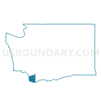
Voting District 153, Clark County, Washington
About
Outline

Summary
| Unique Area Identifier | 683935 |
| Name | Voting District 153 |
| County | Clark County |
| State | Washington |
| Area (square miles) | 0.84 |
| Land Area (square miles) | 0.84 |
| Water Area (square miles) | 0.00 |
| % of Land Area | 100.00 |
| % of Water Area | 0.00 |
| Latitude of the Internal Point | 45.66274440 |
| Longtitude of the Internal Point | -122.64644860 |
Maps

Graphs
Select a template below for downloading or customizing gragh for Voting District 153, Clark County, Washington


Neighbors
Neighoring Voting District (by Name) Neighboring Voting District on the Map
- Voting District 147, Clark County, WA
- Voting District 350, Clark County, WA
- Voting District 360, Clark County, WA
- Voting District 390, Clark County, WA
- Voting District 400, Clark County, WA
Top 10 Neighboring County Subdivision (by Population) Neighboring County Subdivision on the Map
Top 10 Neighboring Place (by Population) Neighboring Place on the Map
- Vancouver city, WA (161,791)
- Hazel Dell CDP, WA (19,435)
- Walnut Grove CDP, WA (9,790)
- Minnehaha CDP, WA (9,771)
Top 10 Neighboring Unified School District (by Population) Neighboring Unified School District on the Map
Top 10 Neighboring State Legislative District Lower Chamber (by Population) Neighboring State Legislative District Lower Chamber on the Map
Top 10 Neighboring State Legislative District Upper Chamber (by Population) Neighboring State Legislative District Upper Chamber on the Map
Top 10 Neighboring 111th Congressional District (by Population) Neighboring 111th Congressional District on the Map
Top 10 Neighboring Census Tract (by Population) Neighboring Census Tract on the Map
- Census Tract 411.10, Clark County, WA (5,849)
- Census Tract 411.05, Clark County, WA (5,206)
- Census Tract 410.10, Clark County, WA (3,385)
- Census Tract 410.11, Clark County, WA (2,994)