


Cook Voting District, Benton County, Washington
About
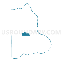
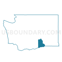
Outline

Summary
| Unique Area Identifier | 683499 |
| Name | Cook Voting District |
| County | Benton County |
| State | Washington |
| Area (square miles) | 24.29 |
| Land Area (square miles) | 24.29 |
| Water Area (square miles) | 0.00 |
| % of Land Area | 100.00 |
| % of Water Area | 0.00 |
| Latitude of the Internal Point | 46.23569460 |
| Longtitude of the Internal Point | -119.54020690 |
Maps

Graphs
Select a template below for downloading or customizing gragh for Cook Voting District, Benton County, Washington


Neighbors
Neighoring Voting District (by Name) Neighboring Voting District on the Map
- Benton East Voting District, Benton County, WA
- Benton West Voting District, Benton County, WA
- Carley Voting District, Benton County, WA
- Chandler Voting District, Benton County, WA
- Dot Voting District, Benton County, WA
- Reese Voting District, Benton County, WA
- South Voting District, Benton County, WA
- Wellington Voting District, Benton County, WA
Top 10 Neighboring County Subdivision (by Population) Neighboring County Subdivision on the Map
- Richland-Kennewick CCD, Benton County, WA (154,811)
- Northwest Benton CCD, Benton County, WA (13,622)