


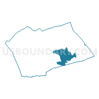
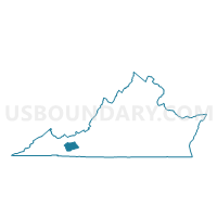
Sheffey Voting District, Wythe County, Virginia
About
Outline

Summary
| Unique Area Identifier | 682717 |
| Name | Sheffey Voting District |
| County | Wythe County |
| State | Virginia |
| Area (square miles) | 29.08 |
| Land Area (square miles) | 28.78 |
| Water Area (square miles) | 0.30 |
| % of Land Area | 98.95 |
| % of Water Area | 1.05 |
| Latitude of the Internal Point | 36.88421320 |
| Longtitude of the Internal Point | -80.95710240 |
Maps

Graphs
Select a template below for downloading or customizing gragh for Sheffey Voting District, Wythe County, Virginia


Neighbors
Neighoring Voting District (by Name) Neighboring Voting District on the Map
- Fort Chiswell Voting District, Wythe County, VA
- Huddle Voting District, Wythe County, VA
- Jackson Memorial Voting District, Wythe County, VA
- Laurel Voting District, Carroll County, VA
- Vaughn Voting District, Carroll County, VA
Top 10 Neighboring County Subdivision (by Population) Neighboring County Subdivision on the Map
- Sulphur Springs district, Carroll County, VA (8,641)
- Lead Mines district, Wythe County, VA (5,017)
- Fort Chiswell district, Wythe County, VA (4,795)
- Speedwell district, Wythe County, VA (4,689)
Top 10 Neighboring Place (by Population) Neighboring Place on the Map
Top 10 Neighboring Unified School District (by Population) Neighboring Unified School District on the Map
Top 10 Neighboring State Legislative District Lower Chamber (by Population) Neighboring State Legislative District Lower Chamber on the Map
Top 10 Neighboring State Legislative District Upper Chamber (by Population) Neighboring State Legislative District Upper Chamber on the Map
Top 10 Neighboring 111th Congressional District (by Population) Neighboring 111th Congressional District on the Map
Top 10 Neighboring Census Tract (by Population) Neighboring Census Tract on the Map
- Census Tract 504.02, Wythe County, VA (5,187)
- Census Tract 803, Carroll County, VA (4,925)
- Census Tract 504.01, Wythe County, VA (4,010)