


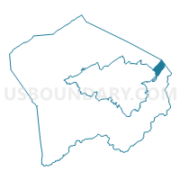
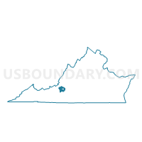
Bonsack Voting District, Roanoke County, Virginia
About
Outline

Summary
| Unique Area Identifier | 682445 |
| Name | Bonsack Voting District |
| County | Roanoke County |
| State | Virginia |
| Area (square miles) | 1.84 |
| Land Area (square miles) | 1.83 |
| Water Area (square miles) | 0.01 |
| % of Land Area | 99.71 |
| % of Water Area | 0.29 |
| Latitude of the Internal Point | 37.31401230 |
| Longtitude of the Internal Point | -79.87080860 |
Maps

Graphs
Select a template below for downloading or customizing gragh for Bonsack Voting District, Roanoke County, Virginia


Neighbors
Neighoring Voting District (by Name) Neighboring Voting District on the Map
- Coyner Springs Voting District, Botetourt County, VA
- Lindenwood Voting District, Roanoke County, VA
- Orchards Voting District, Roanoke County, VA
- Rainbow Forest Voting District, Botetourt County, VA
- Tinker Voting District, Roanoke city, VA
Top 10 Neighboring County Subdivision (by Population) Neighboring County Subdivision on the Map
- Roanoke city, Roanoke city, VA (97,032)
- Hollins district, Roanoke County, VA (19,339)
- Vinton district, Roanoke County, VA (17,818)
- Valley district, Botetourt County, VA (6,319)
- Blue Ridge district, Botetourt County, VA (6,174)
Top 10 Neighboring Place (by Population) Neighboring Place on the Map
Top 10 Neighboring Unified School District (by Population) Neighboring Unified School District on the Map
- Roanoke City Public Schools, VA (97,032)
- Roanoke County Public Schools, VA (92,376)
- Botetourt County Public Schools, VA (33,148)
Top 10 Neighboring State Legislative District Lower Chamber (by Population) Neighboring State Legislative District Lower Chamber on the Map
- State House District 19, VA (78,345)
- State House District 17, VA (73,149)
- State House District 11, VA (73,038)
Top 10 Neighboring State Legislative District Upper Chamber (by Population) Neighboring State Legislative District Upper Chamber on the Map
Top 10 Neighboring 111th Congressional District (by Population) Neighboring 111th Congressional District on the Map
Top 10 Neighboring Census Tract (by Population) Neighboring Census Tract on the Map
- Census Tract 405.01, Botetourt County, VA (6,330)
- Census Tract 312.02, Roanoke County, VA (6,152)
- Census Tract 312.01, Roanoke County, VA (4,971)
- Census Tract 6.01, Roanoke city, VA (4,905)
- Census Tract 6.02, Roanoke city, VA (3,508)
- Census Tract 405.02, Botetourt County, VA (1,406)