


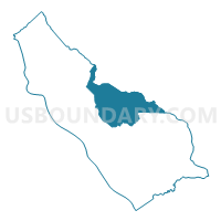
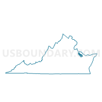
Precinct 2-1, Richmond County, Virginia
About
Outline

Summary
| Unique Area Identifier | 682411 |
| Name | Precinct 2-1 |
| County | Richmond County |
| State | Virginia |
| Area (square miles) | 26.35 |
| Land Area (square miles) | 26.03 |
| Water Area (square miles) | 0.32 |
| % of Land Area | 98.79 |
| % of Water Area | 1.21 |
| Latitude of the Internal Point | 37.97368630 |
| Longtitude of the Internal Point | -76.69405380 |
Maps

Graphs
Select a template below for downloading or customizing gragh for Precinct 2-1, Richmond County, Virginia


Neighbors
Neighoring Voting District (by Name) Neighboring Voting District on the Map
- Voting District 1a, Northumberland County, VA
- Precinct 1-1, Richmond County, VA
- Precinct 1-1, Westmoreland County, VA
- Precinct 1-2, Westmoreland County, VA
- Precinct 3-1, Richmond County, VA
- Precinct 4-1, Richmond County, VA
- Precinct 5-2, Richmond County, VA
Top 10 Neighboring County Subdivision (by Population) Neighboring County Subdivision on the Map
- Cople district, Westmoreland County, VA (5,093)
- Montross district, Westmoreland County, VA (3,445)
- District 2, Richmond County, VA (2,904)
- District 1, Northumberland County, VA (2,629)
- District 5, Richmond County, VA (1,929)
- District 4, Richmond County, VA (1,566)
- District 3, Richmond County, VA (1,487)
- District 1, Richmond County, VA (1,368)
Top 10 Neighboring Place (by Population) Neighboring Place on the Map
Top 10 Neighboring Unified School District (by Population) Neighboring Unified School District on the Map
- Westmoreland County Public Schools, VA (13,956)
- Northumberland County Public Schools, VA (12,330)
- Richmond County Public Schools, VA (9,254)
Top 10 Neighboring State Legislative District Lower Chamber (by Population) Neighboring State Legislative District Lower Chamber on the Map
Top 10 Neighboring State Legislative District Upper Chamber (by Population) Neighboring State Legislative District Upper Chamber on the Map
Top 10 Neighboring 111th Congressional District (by Population) Neighboring 111th Congressional District on the Map
Top 10 Neighboring Census Tract (by Population) Neighboring Census Tract on the Map
- Census Tract 401, Richmond County, VA (5,416)
- Census Tract 101, Westmoreland County, VA (5,234)
- Census Tract 201, Northumberland County, VA (3,903)
- Census Tract 402, Richmond County, VA (3,838)
- Census Tract 102, Westmoreland County, VA (3,498)
Top 10 Neighboring 5-Digit ZIP Code Tabulation Area (by Population) Neighboring 5-Digit ZIP Code Tabulation Area on the Map
- 22572, VA (7,470)
- 22520, VA (5,402)
- 22435, VA (2,439)
- 22469, VA (1,921)
- 22460, VA (1,876)
- 22529, VA (335)