


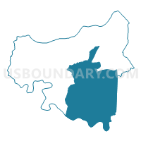
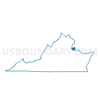
Shiloh Voting District, King George County, Virginia
About
Outline

Summary
| Unique Area Identifier | 681997 |
| Name | Shiloh Voting District |
| County | King George County |
| State | Virginia |
| Area (square miles) | 61.40 |
| Land Area (square miles) | 59.17 |
| Water Area (square miles) | 2.23 |
| % of Land Area | 96.37 |
| % of Water Area | 3.63 |
| Latitude of the Internal Point | 38.22337600 |
| Longtitude of the Internal Point | -77.11305190 |
Maps

Graphs
Select a template below for downloading or customizing gragh for Shiloh Voting District, King George County, Virginia


Neighbors
Neighoring Voting District (by Name) Neighboring Voting District on the Map
- Courthouse Voting District, King George County, VA
- Dahlgren Voting District, King George County, VA
- James Monroe Voting District, King George County, VA
- North Voting District, Essex County, VA
- Port Royal Voting District, Caroline County, VA
- Precinct 3-1, Westmoreland County, VA
- Precinct 4-1, Westmoreland County, VA
Top 10 Neighboring County Subdivision (by Population) Neighboring County Subdivision on the Map
- Washington district, Westmoreland County, VA (8,916)
- James Monroe district, King George County, VA (7,566)
- James Madison district, King George County, VA (6,321)
- Shiloh district, King George County, VA (4,972)
- Dahlgren district, King George County, VA (4,725)
- Port Royal district, Caroline County, VA (4,435)
- North district, Essex County, VA (2,754)
Top 10 Neighboring Place (by Population) Neighboring Place on the Map
Top 10 Neighboring Unified School District (by Population) Neighboring Unified School District on the Map
- Caroline County Public Schools, VA (28,545)
- King George County Public Schools, VA (22,985)
- Westmoreland County Public Schools, VA (13,956)
- Essex County Public Schools, VA (11,151)
Top 10 Neighboring State Legislative District Lower Chamber (by Population) Neighboring State Legislative District Lower Chamber on the Map
Top 10 Neighboring State Legislative District Upper Chamber (by Population) Neighboring State Legislative District Upper Chamber on the Map
Top 10 Neighboring 111th Congressional District (by Population) Neighboring 111th Congressional District on the Map
Top 10 Neighboring Census Tract (by Population) Neighboring Census Tract on the Map
- Census Tract 403, King George County, VA (7,589)
- Census Tract 104, Westmoreland County, VA (5,743)
- Census Tract 401, King George County, VA (4,977)
- Census Tract 402, King George County, VA (4,130)
- Census Tract 301, Caroline County, VA (3,966)
- Census Tract 404, King George County, VA (3,942)
- Census Tract 9506, Essex County, VA (3,865)
- Census Tract 103, Westmoreland County, VA (2,979)
- Census Tract 405, King George County, VA (2,946)