


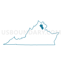
Waterloo Voting District, Fauquier County, Virginia
About
Outline

Summary
| Unique Area Identifier | 681668 |
| Name | Waterloo Voting District |
| County | Fauquier County |
| State | Virginia |
| Area (square miles) | 78.63 |
| Land Area (square miles) | 78.20 |
| Water Area (square miles) | 0.43 |
| % of Land Area | 99.45 |
| % of Water Area | 0.55 |
| Latitude of the Internal Point | 38.71722190 |
| Longtitude of the Internal Point | -77.89646900 |
Maps


Graphs
Select a template below for downloading or customizing gragh for Waterloo Voting District, Fauquier County, Virginia


Neighbors
Neighoring Voting District (by Name) Neighboring Voting District on the Map
- Airlie Voting District, Fauquier County, VA
- Amissville Voting District, Rappahannock County, VA
- Casanova Voting District, Fauquier County, VA
- Courthouse Voting District, Fauquier County, VA
- Flint Hill Voting District, Rappahannock County, VA
- Jeffersonton Voting District, Culpeper County, VA
- Leeds Voting District, Fauquier County, VA
- Marshall Voting District, Fauquier County, VA
- Opal Voting District, Fauquier County, VA
- Remington Voting District, Fauquier County, VA
- The Plains Voting District, Fauquier County, VA
- Warrenton Voting District, Fauquier County, VA
Top 10 Neighboring County Subdivision (by Population) Neighboring County Subdivision on the Map
- Center district, Fauquier County, VA (15,064)
- Lee district, Fauquier County, VA (13,314)
- Cedar Run district, Fauquier County, VA (12,379)
- Marshall district, Fauquier County, VA (12,294)
- Scott district, Fauquier County, VA (12,152)
- Jefferson district, Culpeper County, VA (6,447)
- Jackson district, Rappahannock County, VA (1,597)
- Wakefield district, Rappahannock County, VA (1,536)
Top 10 Neighboring Place (by Population) Neighboring Place on the Map
Top 10 Neighboring Unified School District (by Population) Neighboring Unified School District on the Map
- Fauquier County Public Schools, VA (65,203)
- Culpeper County Public Schools, VA (46,689)
- Rappahannock County Public Schools, VA (7,373)
Top 10 Neighboring State Legislative District Lower Chamber (by Population) Neighboring State Legislative District Lower Chamber on the Map
- State House District 88, VA (93,126)
- State House District 30, VA (90,008)
- State House District 31, VA (88,587)
- State House District 18, VA (82,817)
- State House District 15, VA (78,102)
Top 10 Neighboring State Legislative District Upper Chamber (by Population) Neighboring State Legislative District Upper Chamber on the Map
- State Senate District 17, VA (232,435)
- State Senate District 27, VA (227,068)
- State Senate District 26, VA (201,456)
Top 10 Neighboring 111th Congressional District (by Population) Neighboring 111th Congressional District on the Map
- Congressional District 10, VA (869,437)
- Congressional District 1, VA (786,237)
- Congressional District 7, VA (757,917)
Top 10 Neighboring Census Tract (by Population) Neighboring Census Tract on the Map
- Census Tract 9301.02, Culpeper County, VA (8,301)
- Census Tract 9303.02, Fauquier County, VA (7,449)
- Census Tract 9301, Fauquier County, VA (5,551)
- Census Tract 9502, Rappahannock County, VA (4,681)
- Census Tract 9303.03, Fauquier County, VA (3,613)
- Census Tract 9302.04, Fauquier County, VA (3,367)
- Census Tract 9302.03, Fauquier County, VA (2,702)
- Census Tract 9302.06, Fauquier County, VA (2,133)
- Census Tract 9302.05, Fauquier County, VA (1,678)
- Census Tract 9302.07, Fauquier County, VA (1,660)
Top 10 Neighboring 5-Digit ZIP Code Tabulation Area (by Population) Neighboring 5-Digit ZIP Code Tabulation Area on the Map
- 20187, VA (15,252)
- 20186, VA (14,557)
- 20115, VA (5,838)
- 20106, VA (5,142)
- 20198, VA (2,492)
- 22724, VA (2,282)
- 22639, VA (560)