


Skinquarter Voting District, Chesterfield County, Virginia
About
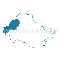
Outline

Summary
| Unique Area Identifier | 681295 |
| Name | Skinquarter Voting District |
| County | Chesterfield County |
| State | Virginia |
| Area (square miles) | 51.51 |
| Land Area (square miles) | 50.65 |
| Water Area (square miles) | 0.86 |
| % of Land Area | 98.34 |
| % of Water Area | 1.66 |
| Latitude of the Internal Point | 37.42414080 |
| Longtitude of the Internal Point | -77.77060140 |
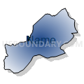
Maps


Graphs
Select a template below for downloading or customizing gragh for Skinquarter Voting District, Chesterfield County, Virginia


Neighbors
Neighoring Voting District (by Name) Neighboring Voting District on the Map
- Brandermill Voting District, Chesterfield County, VA
- Cosby Voting District, Chesterfield County, VA
- Evergreen Voting District, Chesterfield County, VA
- Graceland Voting District, Powhatan County, VA
- Midlothian Voting District, Chesterfield County, VA
- Voting District Number Five, Amelia County, VA
- Voting District Number Two, Amelia County, VA
- Powhatan Station Voting District, Powhatan County, VA
- Swift Creek Voting District, Chesterfield County, VA
- Winterpock Voting District, Chesterfield County, VA
- Woolridge Voting District, Chesterfield County, VA
Top 10 Neighboring County Subdivision (by Population) Neighboring County Subdivision on the Map
- Matoaca district, Chesterfield County, VA (74,985)
- Midlothian district, Chesterfield County, VA (58,880)
- Clover Hill district, Chesterfield County, VA (55,546)
- District 2, Powhatan County, VA (5,525)
- District 2, Amelia County, VA (2,666)
- District 5, Amelia County, VA (2,342)
Top 10 Neighboring Place (by Population) Neighboring Place on the Map
Top 10 Neighboring Unified School District (by Population) Neighboring Unified School District on the Map
- Chesterfield County Public Schools, VA (316,236)
- Powhatan County Public Schools, VA (28,046)
- Amelia County Public Schools, VA (12,690)
Top 10 Neighboring State Legislative District Lower Chamber (by Population) Neighboring State Legislative District Lower Chamber on the Map
- State House District 65, VA (89,790)
- State House District 66, VA (88,542)
- State House District 27, VA (87,915)
- State House District 61, VA (71,425)
Top 10 Neighboring State Legislative District Upper Chamber (by Population) Neighboring State Legislative District Upper Chamber on the Map
Top 10 Neighboring 111th Congressional District (by Population) Neighboring 111th Congressional District on the Map
Top 10 Neighboring Census Tract (by Population) Neighboring Census Tract on the Map
- Census Tract 1009.27, Chesterfield County, VA (7,324)
- Census Tract 9301, Amelia County, VA (6,913)
- Census Tract 1009.12, Chesterfield County, VA (6,268)
- Census Tract 1010.07, Chesterfield County, VA (6,264)
- Census Tract 1010.09, Chesterfield County, VA (5,841)
- Census Tract 9302, Amelia County, VA (5,777)
- Census Tract 5001.02, Powhatan County, VA (5,519)
- Census Tract 1009.28, Chesterfield County, VA (5,077)
- Census Tract 1010.04, Chesterfield County, VA (4,727)
- Census Tract 1010.03, Chesterfield County, VA (4,515)
Top 10 Neighboring 5-Digit ZIP Code Tabulation Area (by Population) Neighboring 5-Digit ZIP Code Tabulation Area on the Map
- 23112, VA (46,982)
- 23832, VA (33,739)
- 23139, VA (24,425)
- 23114, VA (17,449)
- 23002, VA (10,439)
- 23120, VA (5,971)