


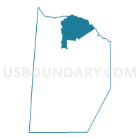
Elmore Voting District, Brunswick County, Virginia
About
Outline

Summary
| Unique Area Identifier | 681202 |
| Name | Elmore Voting District |
| County | Brunswick County |
| State | Virginia |
| Area (square miles) | 42.31 |
| Land Area (square miles) | 42.24 |
| Water Area (square miles) | 0.07 |
| % of Land Area | 99.83 |
| % of Water Area | 0.17 |
| Latitude of the Internal Point | 36.94132800 |
| Longtitude of the Internal Point | -77.82162140 |
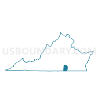
Maps

Graphs
Select a template below for downloading or customizing gragh for Elmore Voting District, Brunswick County, Virginia


Neighbors
Neighoring Voting District (by Name) Neighboring Voting District on the Map
- Alberta Voting District, Brunswick County, VA
- Danieltown Voting District, Brunswick County, VA
- King's Store Voting District, Brunswick County, VA
- McKenney Voting District, Dinwiddie County, VA
- Sturgeon Voting District, Brunswick County, VA
- White Oak Voting District, Dinwiddie County, VA
Top 10 Neighboring County Subdivision (by Population) Neighboring County Subdivision on the Map
- District 5, Dinwiddie County, VA (5,516)
- District 1, Dinwiddie County, VA (5,321)
- Sturgeon district, Brunswick County, VA (4,958)
- Red Oak district, Brunswick County, VA (3,029)
Top 10 Neighboring Place (by Population) Neighboring Place on the Map
Top 10 Neighboring Unified School District (by Population) Neighboring Unified School District on the Map
Top 10 Neighboring State Legislative District Lower Chamber (by Population) Neighboring State Legislative District Lower Chamber on the Map
Top 10 Neighboring State Legislative District Upper Chamber (by Population) Neighboring State Legislative District Upper Chamber on the Map
Top 10 Neighboring 111th Congressional District (by Population) Neighboring 111th Congressional District on the Map
Top 10 Neighboring Census Tract (by Population) Neighboring Census Tract on the Map
- Census Tract 8401, Dinwiddie County, VA (5,720)
- Census Tract 9301, Brunswick County, VA (3,663)
- Census Tract 9801, Dinwiddie County, VA (0)