


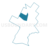
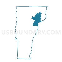
Wheelock Voting District, Caledonia County, Vermont
About
Outline

Summary
| Unique Area Identifier | 680733 |
| Name | Wheelock Voting District |
| County | Caledonia County |
| State | Vermont |
| Area (square miles) | 39.82 |
| Land Area (square miles) | 39.50 |
| Water Area (square miles) | 0.32 |
| % of Land Area | 99.20 |
| % of Water Area | 0.80 |
| Latitude of the Internal Point | 44.56120200 |
| Longtitude of the Internal Point | -72.16053820 |
Maps

Graphs
Select a template below for downloading or customizing gragh for Wheelock Voting District, Caledonia County, Vermont


Neighbors
Neighoring Voting District (by Name) Neighboring Voting District on the Map
- Danville Voting District, Caledonia County, VT
- Glover Voting District, Orleans County, VT
- Greensboro Voting District, Orleans County, VT
- Lyndon Voting District, Caledonia County, VT
- Sheffield Voting District, Caledonia County, VT
- St. Johnsbury Voting District, Caledonia County, VT
- Stannard Voting District, Caledonia County, VT
- Sutton Voting District, Caledonia County, VT
Top 10 Neighboring County Subdivision (by Population) Neighboring County Subdivision on the Map
- St. Johnsbury town, Caledonia County, VT (7,603)
- Lyndon town, Caledonia County, VT (5,981)
- Danville town, Caledonia County, VT (2,196)
- Glover town, Orleans County, VT (1,122)
- Sutton town, Caledonia County, VT (1,029)
- Wheelock town, Caledonia County, VT (811)
- Greensboro town, Orleans County, VT (762)
- Sheffield town, Caledonia County, VT (703)
- Stannard town, Caledonia County, VT (216)
Top 10 Neighboring Elementary School District (by Population) Neighboring Elementary School District on the Map
- St. Johnsbury School District, VT (7,603)
- Lyndon School District, VT (5,981)
- Millers Run Union School District 37, VT (1,514)
- Glover School District, VT (1,122)
- Sutton School District, VT (1,029)
- Lakeview Union School District 43, VT (978)
Top 10 Neighboring Secondary School District (by Population) Neighboring Secondary School District on the Map
- Lake Region Union High School District 24, VT (7,382)
- Hazen Union High School District 26, VT (4,894)
Top 10 Neighboring Unified School District (by Population) Neighboring Unified School District on the Map
Top 10 Neighboring State Legislative District Lower Chamber (by Population) Neighboring State Legislative District Lower Chamber on the Map
- Caledonia-4 State House District, VT (8,763)
- Orleans-Caledonia-1 State House District, VT (8,355)
- Caledonia-3 State House District, VT (7,603)
- Caledonia-Washington-1 State House District, VT (4,361)
- Caledonia-2 State House District, VT (4,161)
Top 10 Neighboring State Legislative District Upper Chamber (by Population) Neighboring State Legislative District Upper Chamber on the Map
Top 10 Neighboring 111th Congressional District (by Population) Neighboring 111th Congressional District on the Map
Top 10 Neighboring Census Tract (by Population) Neighboring Census Tract on the Map
- Census Tract 9570, Caledonia County, VT (4,275)
- Census Tract 9574, Caledonia County, VT (3,852)
- Census Tract 9573, Caledonia County, VT (3,335)
- Census Tract 9576, Caledonia County, VT (2,196)
- Census Tract 9520, Orleans County, VT (1,884)
Top 10 Neighboring 5-Digit ZIP Code Tabulation Area (by Population) Neighboring 5-Digit ZIP Code Tabulation Area on the Map
- 05819, VT (9,444)
- 05851, VT (6,528)
- 05828, VT (1,928)
- 05867, VT (899)
- 05839, VT (775)
- 05866, VT (732)
- 05842, VT (522)
- 05841, VT (425)