


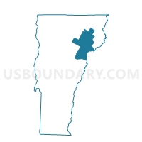
Newark Voting District, Caledonia County, Vermont
About
Outline

Summary
| Unique Area Identifier | 680729 |
| Name | Newark Voting District |
| County | Caledonia County |
| State | Vermont |
| Area (square miles) | 37.21 |
| Land Area (square miles) | 36.75 |
| Water Area (square miles) | 0.47 |
| % of Land Area | 98.75 |
| % of Water Area | 1.25 |
| Latitude of the Internal Point | 44.72934170 |
| Longtitude of the Internal Point | -71.93898400 |
Maps


Graphs
Select a template below for downloading or customizing gragh for Newark Voting District, Caledonia County, Vermont


Neighbors
Neighoring Voting District (by Name) Neighboring Voting District on the Map
- Brighton Voting District, Essex County, VT
- Burke Voting District, Caledonia County, VT
- East Haven Voting District, Essex County, VT
- Ferdinand Voting District, Essex County, VT
- Sutton Voting District, Caledonia County, VT
- Westmore Voting District, Orleans County, VT
Top 10 Neighboring County Subdivision (by Population) Neighboring County Subdivision on the Map
- Burke town, Caledonia County, VT (1,753)
- Brighton town, Essex County, VT (1,222)
- Sutton town, Caledonia County, VT (1,029)
- Newark town, Caledonia County, VT (581)
- Westmore town, Orleans County, VT (350)
- East Haven town, Essex County, VT (290)
- Ferdinand town, Essex County, VT (32)
Top 10 Neighboring Elementary School District (by Population) Neighboring Elementary School District on the Map
- Burke School District, VT (1,753)
- Brighton School District, VT (1,222)
- Sutton School District, VT (1,029)
- Newark School District, VT (581)
- Westmore School District, VT (350)
Top 10 Neighboring Secondary School District (by Population) Neighboring Secondary School District on the Map
- North Country Union High School District 22, VT (18,017)
- Lake Region Union High School District 24, VT (7,382)
Top 10 Neighboring Unified School District (by Population) Neighboring Unified School District on the Map
Top 10 Neighboring State Legislative District Lower Chamber (by Population) Neighboring State Legislative District Lower Chamber on the Map
Top 10 Neighboring State Legislative District Upper Chamber (by Population) Neighboring State Legislative District Upper Chamber on the Map
Top 10 Neighboring 111th Congressional District (by Population) Neighboring 111th Congressional District on the Map
Top 10 Neighboring Census Tract (by Population) Neighboring Census Tract on the Map
- Census Tract 9570, Caledonia County, VT (4,275)
- Census Tract 9505, Essex County, VT (3,238)
- Census Tract 9519, Orleans County, VT (2,424)
- Census Tract 9571, Caledonia County, VT (2,246)
- Census Tract 9501, Essex County, VT (1,846)
- Census Tract 9502, Essex County, VT (1,222)
Top 10 Neighboring 5-Digit ZIP Code Tabulation Area (by Population) Neighboring 5-Digit ZIP Code Tabulation Area on the Map
- 05860, VT (2,557)
- 05871, VT (1,638)
- 05846, VT (1,252)
- 05832, VT (982)
- 05867, VT (899)
- 05905, VT (827)
- 05837, VT (353)