


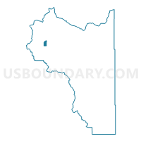
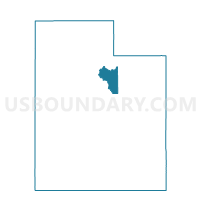
Charleston Town Voting District, Wasatch County, Utah
About
Outline

Summary
| Unique Area Identifier | 680345 |
| Name | Charleston Town Voting District |
| County | Wasatch County |
| State | Utah |
| Area (square miles) | 2.00 |
| Land Area (square miles) | 1.80 |
| Water Area (square miles) | 0.20 |
| % of Land Area | 90.07 |
| % of Water Area | 9.93 |
| Latitude of the Internal Point | 40.46695790 |
| Longtitude of the Internal Point | -111.46513420 |
Maps

Graphs
Select a template below for downloading or customizing gragh for Charleston Town Voting District, Wasatch County, Utah


Neighbors
Neighoring Voting District (by Name) Neighboring Voting District on the Map
- Charleston Town - Annex Voting District, Wasatch County, UT
- Wasatch County - South Voting District, Wasatch County, UT
- Wasatch County - Southfields Voting District, Wasatch County, UT
- Wasatch County - West Voting District, Wasatch County, UT