


Voting District 2867, Salt Lake County, Utah
About
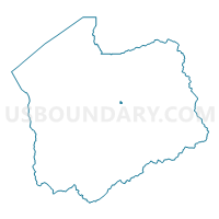
Outline

Summary
| Unique Area Identifier | 679174 |
| Name | Voting District 2867 |
| County | Salt Lake County |
| State | Utah |
| Area (square miles) | 0.08 |
| Land Area (square miles) | 0.08 |
| Water Area (square miles) | 0.00 |
| % of Land Area | 100.00 |
| % of Water Area | 0.00 |
| Latitude of the Internal Point | 40.68906430 |
| Longtitude of the Internal Point | -111.86891010 |
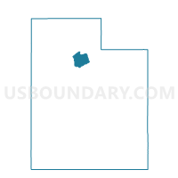
Maps

Graphs
Select a template below for downloading or customizing gragh for Voting District 2867, Salt Lake County, Utah


Neighbors
Neighoring Voting District (by Name) Neighboring Voting District on the Map
- Voting District 2754, Salt Lake County, UT
- Voting District 2869, Salt Lake County, UT
- Voting District 2886, Salt Lake County, UT
- Voting District 4106, Salt Lake County, UT
- Voting District 4108, Salt Lake County, UT
- Voting District 4120, Salt Lake County, UT
Top 10 Neighboring County Subdivision (by Population) Neighboring County Subdivision on the Map
Top 10 Neighboring Place (by Population) Neighboring Place on the Map
Top 10 Neighboring Unified School District (by Population) Neighboring Unified School District on the Map
Top 10 Neighboring State Legislative District Lower Chamber (by Population) Neighboring State Legislative District Lower Chamber on the Map
Top 10 Neighboring State Legislative District Upper Chamber (by Population) Neighboring State Legislative District Upper Chamber on the Map
Top 10 Neighboring 111th Congressional District (by Population) Neighboring 111th Congressional District on the Map
Top 10 Neighboring Census Tract (by Population) Neighboring Census Tract on the Map
- Census Tract 1118.01, Salt Lake County, UT (5,276)
- Census Tract 1117.02, Salt Lake County, UT (4,361)
- Census Tract 1119.03, Salt Lake County, UT (3,916)
- Census Tract 1119.05, Salt Lake County, UT (3,583)