


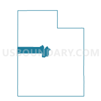
Callaco Voting District, Juab County, Utah
About
Outline

Summary
| Unique Area Identifier | 678897 |
| Name | Callaco Voting District |
| County | Juab County |
| State | Utah |
| Area (square miles) | 1,788.42 |
| Land Area (square miles) | 1,782.72 |
| Water Area (square miles) | 5.70 |
| % of Land Area | 99.68 |
| % of Water Area | 0.32 |
| Latitude of the Internal Point | 39.77403060 |
| Longtitude of the Internal Point | -113.36376420 |
Maps


Graphs
Select a template below for downloading or customizing gragh for Callaco Voting District, Juab County, Utah


Neighbors
Neighoring Voting District (by Name) Neighboring Voting District on the Map
- Abraham 14 Voting District, Millard County, UT
- Dugway 02 Voting District, Tooele County, UT
- Eureka Voting District, Juab County, UT
- Garrison 16 Voting District, Millard County, UT
- Ibapah Voting District, Tooele County, UT
- Nephi 3 Voting District, Juab County, UT
- Sutherland 20 Voting District, Millard County, UT
- Terra Voting District, Tooele County, UT
- WP COUNTY MAILING VTD 10, White Pine County, NV
Top 10 Neighboring County Subdivision (by Population) Neighboring County Subdivision on the Map
- Delta CCD, Millard County, UT (7,704)
- Dugway-Wendover CCD, Tooele County, UT (2,477)
- Eureka CCD, Juab County, UT (693)
- Baker CCD, White Pine County, NV (363)
- West Juab CCD, Juab County, UT (187)
- Garrison-Sevier Lake CCD, Millard County, UT (160)
Top 10 Neighboring Unified School District (by Population) Neighboring Unified School District on the Map
- Tooele School District, UT (58,218)
- Millard School District, UT (12,503)
- White Pine County School District, NV (10,030)
- Juab School District, UT (9,367)
- Tintic School District, UT (879)
Top 10 Neighboring State Legislative District Lower Chamber (by Population) Neighboring State Legislative District Lower Chamber on the Map
- Assembly District 35, NV (51,108)
- State House District 1, UT (34,122)
- State House District 68, UT (31,934)
Top 10 Neighboring State Legislative District Upper Chamber (by Population) Neighboring State Legislative District Upper Chamber on the Map
- Rural Nevada Senatorial District, NV (97,335)
- State Senate District 28, UT (94,905)
- State Senate District 24, UT (85,639)
Top 10 Neighboring 111th Congressional District (by Population) Neighboring 111th Congressional District on the Map
- Congressional District 3, UT (966,232)
- Congressional District 1, UT (906,660)
- Congressional District 2, NV (836,562)
Top 10 Neighboring Census Tract (by Population) Neighboring Census Tract on the Map
- Census Tract 102, Juab County, UT (4,681)
- Census Tract 9742, Millard County, UT (3,037)
- Census Tract 1306, Tooele County, UT (2,477)
- Census Tract 9701, White Pine County, NV (1,882)