


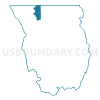
Lewiston 02 Voting District, Cache County, Utah
About
Outline

Summary
| Unique Area Identifier | 678574 |
| Name | Lewiston 02 Voting District |
| County | Cache County |
| State | Utah |
| Area (square miles) | 17.05 |
| Land Area (square miles) | 16.86 |
| Water Area (square miles) | 0.19 |
| % of Land Area | 98.90 |
| % of Water Area | 1.10 |
| Latitude of the Internal Point | 41.95608370 |
| Longtitude of the Internal Point | -111.90351890 |
Maps

Graphs
Select a template below for downloading or customizing gragh for Lewiston 02 Voting District, Cache County, Utah


Neighbors
Neighoring Voting District (by Name) Neighboring Voting District on the Map
- Amalga Voting District, Cache County, UT
- Cornish Voting District, Cache County, UT
- Fairview 9 Voting District, Franklin County, ID
- Lewiston 01 Voting District, Cache County, UT
- Richmond 02 Voting District, Cache County, UT
- Trenton Voting District, Cache County, UT
Top 10 Neighboring County Subdivision (by Population) Neighboring County Subdivision on the Map
- Smithfield CCD, Cache County, UT (12,379)
- Preston CCD, Franklin County, ID (9,398)
- Lewiston CCD, Cache County, UT (6,162)
Top 10 Neighboring Place (by Population) Neighboring Place on the Map
Top 10 Neighboring Unified School District (by Population) Neighboring Unified School District on the Map
Top 10 Neighboring State Legislative District Lower Chamber (by Population) Neighboring State Legislative District Lower Chamber on the Map
- State House District 31, ID (45,173)
- State House District 3, UT (38,268)
- State House District 2, UT (34,283)
Top 10 Neighboring State Legislative District Upper Chamber (by Population) Neighboring State Legislative District Upper Chamber on the Map
Top 10 Neighboring 111th Congressional District (by Population) Neighboring 111th Congressional District on the Map
Top 10 Neighboring Census Tract (by Population) Neighboring Census Tract on the Map
- Census Tract 3, Cache County, UT (7,492)
- Census Tract 9702, Franklin County, ID (6,718)
- Census Tract 1.01, Cache County, UT (4,599)
- Census Tract 1.02, Cache County, UT (1,563)
Top 10 Neighboring 5-Digit ZIP Code Tabulation Area (by Population) Neighboring 5-Digit ZIP Code Tabulation Area on the Map
- 84335, UT (11,372)
- 83263, ID (9,258)
- 84333, UT (2,722)
- 84320, UT (2,237)
- 84338, UT (481)
- 84308, UT (325)