


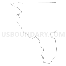
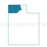
Promontory Voting District, Box Elder County, Utah
About
Outline
Summary
| Unique Area Identifier | 678474 |
| Name | Promontory Voting District |
| County | Box Elder County |
| State | Utah |
| Area (square miles) | 539.18 |
| Land Area (square miles) | 512.47 |
| Water Area (square miles) | 26.72 |
| % of Land Area | 95.05 |
| % of Water Area | 4.95 |
| Latitude of the Internal Point | 41.56790130 |
| Longtitude of the Internal Point | -112.54055940 |
Maps

Graphs
Select a template below for downloading or customizing gragh for Promontory Voting District, Box Elder County, Utah


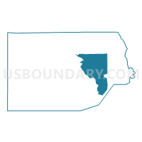
Neighbors
Neighoring Voting District (by Name) Neighboring Voting District on the Map
- Corinne Unincorporated 1 Voting District, Box Elder County, UT
- Corinne Unincorporated 2 Voting District, Box Elder County, UT
- Great Salt Lake Voting District, Box Elder County, UT
- Grouse Creek Voting District, Box Elder County, UT
- Howell Municipality Voting District, Box Elder County, UT
- Howell Unincorporated Voting District, Box Elder County, UT
- Snowville Unincorporated Voting District, Box Elder County, UT
- Tremonton West Voting District, Box Elder County, UT
Top 10 Neighboring County Subdivision (by Population) Neighboring County Subdivision on the Map
- Tremonton CCD, Box Elder County, UT (19,959)
- Howell-Snowville CCD, Box Elder County, UT (2,769)
- West Box Elder CCD, Box Elder County, UT (383)