


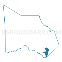
Voting District 0082, Montgomery County, Texas
About
Outline

Summary
| Unique Area Identifier | 675941 |
| Name | Voting District 0082 |
| County | Montgomery County |
| State | Texas |
| Area (square miles) | 14.75 |
| Land Area (square miles) | 14.51 |
| Water Area (square miles) | 0.25 |
| % of Land Area | 98.33 |
| % of Water Area | 1.67 |
| Latitude of the Internal Point | 30.09145700 |
| Longtitude of the Internal Point | -95.25894040 |
Maps

Graphs
Select a template below for downloading or customizing gragh for Voting District 0082, Montgomery County, Texas


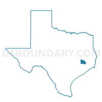
Neighbors
Neighoring Voting District (by Name) Neighboring Voting District on the Map
- Voting District 0014, Montgomery County, TX
- Voting District 0026, Montgomery County, TX
- Voting District 0037, Montgomery County, TX
- Voting District 0046, Montgomery County, TX
- Voting District 0052, Montgomery County, TX
- Voting District 0599, Harris County, TX
Top 10 Neighboring County Subdivision (by Population) Neighboring County Subdivision on the Map
- Houston CCD, Harris County, TX (3,075,388)
- Southeast Montgomery CCD, Montgomery County, TX (318,202)
Top 10 Neighboring Place (by Population) Neighboring Place on the Map
Top 10 Neighboring Unified School District (by Population) Neighboring Unified School District on the Map
- Conroe Independent School District, TX (258,544)
- Humble Independent School District, TX (167,483)
- New Caney Independent School District, TX (50,152)
Top 10 Neighboring State Legislative District Lower Chamber (by Population) Neighboring State Legislative District Lower Chamber on the Map
- State House District 15, TX (222,505)
- State House District 150, TX (212,484)
- State House District 16, TX (203,299)
- State House District 18, TX (150,998)
Top 10 Neighboring State Legislative District Upper Chamber (by Population) Neighboring State Legislative District Upper Chamber on the Map
Top 10 Neighboring 111th Congressional District (by Population) Neighboring 111th Congressional District on the Map
Top 10 Neighboring Census Tract (by Population) Neighboring Census Tract on the Map
- Census Tract 6923, Montgomery County, TX (15,803)
- Census Tract 6926.02, Montgomery County, TX (10,150)
- Census Tract 6924, Montgomery County, TX (8,609)
- Census Tract 6925, Montgomery County, TX (8,331)
- Census Tract 2511, Harris County, TX (7,400)
- Census Tract 6920.02, Montgomery County, TX (5,961)