


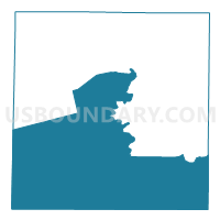
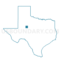
Voting District 0003, Mitchell County, Texas
About
Outline

Summary
| Unique Area Identifier | 675900 |
| Name | Voting District 0003 |
| County | Mitchell County |
| State | Texas |
| Area (square miles) | 392.47 |
| Land Area (square miles) | 390.20 |
| Water Area (square miles) | 2.28 |
| % of Land Area | 99.42 |
| % of Water Area | 0.58 |
| Latitude of the Internal Point | 32.18979660 |
| Longtitude of the Internal Point | -100.90880130 |
Maps

Graphs
Select a template below for downloading or customizing gragh for Voting District 0003, Mitchell County, Texas


Neighbors
Neighoring Voting District (by Name) Neighboring Voting District on the Map
- Voting District 0001, Coke County, TX
- Voting District 0001, Mitchell County, TX
- Voting District 0002, Mitchell County, TX
- Voting District 0003, Sterling County, TX
- Voting District 0004, Mitchell County, TX
- Voting District 0004, Sterling County, TX
- Voting District 0008, Nolan County, TX
- Voting District 0025, Mitchell County, TX
- Voting District 0207, Howard County, TX
- Voting District 0208, Howard County, TX
Top 10 Neighboring County Subdivision (by Population) Neighboring County Subdivision on the Map
- Big Spring CCD, Howard County, TX (30,743)
- Colorado City CCD, Mitchell County, TX (7,333)
- Roscoe CCD, Nolan County, TX (2,049)
- Coahoma CCD, Howard County, TX (2,022)
- Robert Lee CCD, Coke County, TX (1,644)
- Sterling City CCD, Sterling County, TX (1,143)
- Loraine CCD, Mitchell County, TX (1,097)
- Westbrook CCD, Mitchell County, TX (973)
Top 10 Neighboring Place (by Population) Neighboring Place on the Map
Top 10 Neighboring Unified School District (by Population) Neighboring Unified School District on the Map
- Colorado Independent School District, TX (7,498)
- Coahoma Independent School District, TX (3,513)
- Forsan Independent School District, TX (2,198)
- Robert Lee Independent School District, TX (1,628)
- Sterling City Independent School District, TX (1,143)
- Loraine Independent School District, TX (997)
- Westbrook Independent School District, TX (900)
- Highland Independent School District, TX (362)
Top 10 Neighboring State Legislative District Lower Chamber (by Population) Neighboring State Legislative District Lower Chamber on the Map
- State House District 71, TX (146,722)
- State House District 85, TX (143,267)
- State House District 72, TX (139,868)
Top 10 Neighboring State Legislative District Upper Chamber (by Population) Neighboring State Legislative District Upper Chamber on the Map
Top 10 Neighboring 111th Congressional District (by Population) Neighboring 111th Congressional District on the Map
Top 10 Neighboring Census Tract (by Population) Neighboring Census Tract on the Map
- Census Tract 9502, Mitchell County, TX (7,333)
- Census Tract 9509, Howard County, TX (3,577)
- Census Tract 9505, Nolan County, TX (2,736)
- Census Tract 9504, Mitchell County, TX (2,070)
- Census Tract 9502, Howard County, TX (2,022)
- Census Tract 9502, Coke County, TX (1,644)
- Census Tract 9501, Sterling County, TX (1,143)
Top 10 Neighboring 5-Digit ZIP Code Tabulation Area (by Population) Neighboring 5-Digit ZIP Code Tabulation Area on the Map
- 79512, TX (8,197)
- 76945, TX (1,665)
- 79511, TX (1,338)
- 76951, TX (1,143)
- 79565, TX (295)
- 79535, TX (183)