


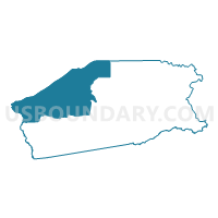
Voting District 0306, Madison County, Texas
About
Outline

Summary
| Unique Area Identifier | 675754 |
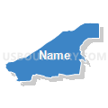
| Name | Voting District 0306 |
| County | Madison County |
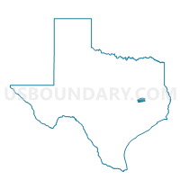
| State | Texas |
| Area (square miles) | 104.32 |
| Land Area (square miles) | 103.14 |
| Water Area (square miles) | 1.18 |
| % of Land Area | 98.87 |
| % of Water Area | 1.13 |
| Latitude of the Internal Point | 30.99819520 |
| Longtitude of the Internal Point | -96.08098200 |
Maps

Graphs
Select a template below for downloading or customizing gragh for Voting District 0306, Madison County, Texas


Neighbors
Neighoring Voting District (by Name) Neighboring Voting District on the Map
- Voting District 0003, Leon County, TX
- Voting District 0004, Leon County, TX
- Voting District 0006, Brazos County, TX
- Voting District 0019, Robertson County, TX
- Voting District 0204, Madison County, TX
- Voting District 0305, Madison County, TX
- Voting District 0407, Madison County, TX
- Voting District 0408, Madison County, TX
Top 10 Neighboring County Subdivision (by Population) Neighboring County Subdivision on the Map
- Northeast Brazos CCD, Brazos County, TX (15,438)
- Madisonville CCD, Madison County, TX (7,289)
- Franklin CCD, Robertson County, TX (5,790)
- Centerville CCD, Leon County, TX (4,695)
- Normangee CCD, Leon County, TX (3,375)
- North Zulch CCD, Madison County, TX (2,774)
Top 10 Neighboring Place (by Population) Neighboring Place on the Map
Top 10 Neighboring Unified School District (by Population) Neighboring Unified School District on the Map
- Bryan Independent School District, TX (92,346)
- Madisonville Consolidated Independent School District, TX (13,498)
- Centerville Independent School District, TX (4,279)
- Normangee Independent School District, TX (3,379)
- North Zulch Independent School District, TX (1,809)
Top 10 Neighboring State Legislative District Lower Chamber (by Population) Neighboring State Legislative District Lower Chamber on the Map
Top 10 Neighboring State Legislative District Upper Chamber (by Population) Neighboring State Legislative District Upper Chamber on the Map
Top 10 Neighboring 111th Congressional District (by Population) Neighboring 111th Congressional District on the Map
Top 10 Neighboring Census Tract (by Population) Neighboring Census Tract on the Map
- Census Tract 9502, Leon County, TX (5,414)
- Census Tract 9503, Leon County, TX (4,695)
- Census Tract 9603, Robertson County, TX (4,520)
- Census Tract 3, Madison County, TX (2,774)
- Census Tract 2, Madison County, TX (2,357)
- Census Tract 1.03, Brazos County, TX (1,837)
Top 10 Neighboring 5-Digit ZIP Code Tabulation Area (by Population) Neighboring 5-Digit ZIP Code Tabulation Area on the Map
- 77808, TX (10,634)
- 77864, TX (7,647)
- 77859, TX (6,981)
- 77856, TX (5,096)
- 75852, TX (3,762)
- 77871, TX (3,368)
- 77872, TX (1,716)
- 75850, TX (671)