


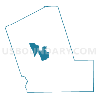
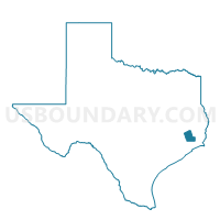
Voting District 0029, Liberty County, Texas
About
Outline

Summary
| Unique Area Identifier | 675446 |
| Name | Voting District 0029 |
| County | Liberty County |
| State | Texas |
| Area (square miles) | 35.93 |
| Land Area (square miles) | 35.50 |
| Water Area (square miles) | 0.42 |
| % of Land Area | 98.82 |
| % of Water Area | 1.18 |
| Latitude of the Internal Point | 30.16934760 |
| Longtitude of the Internal Point | -94.88205520 |
Maps

Graphs
Select a template below for downloading or customizing gragh for Voting District 0029, Liberty County, Texas


Neighbors
Neighoring Voting District (by Name) Neighboring Voting District on the Map
- Voting District 0003, Liberty County, TX
- Voting District 0009, Liberty County, TX
- Voting District 0021, Liberty County, TX
- Voting District 0025, Liberty County, TX
- Voting District 0026, Liberty County, TX
- Voting District 0034, Liberty County, TX
Top 10 Neighboring County Subdivision (by Population) Neighboring County Subdivision on the Map
Top 10 Neighboring Place (by Population) Neighboring Place on the Map
Top 10 Neighboring Unified School District (by Population) Neighboring Unified School District on the Map
Top 10 Neighboring State Legislative District Lower Chamber (by Population) Neighboring State Legislative District Lower Chamber on the Map
Top 10 Neighboring State Legislative District Upper Chamber (by Population) Neighboring State Legislative District Upper Chamber on the Map
Top 10 Neighboring 111th Congressional District (by Population) Neighboring 111th Congressional District on the Map
Top 10 Neighboring Census Tract (by Population) Neighboring Census Tract on the Map
- Census Tract 7008, Liberty County, TX (8,892)
- Census Tract 7004, Liberty County, TX (6,334)
- Census Tract 7009, Liberty County, TX (6,059)