


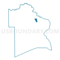
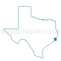
Voting District 0035, Jefferson County, Texas
About
Outline

Summary
| Unique Area Identifier | 675082 |
| Name | Voting District 0035 |
| County | Jefferson County |
| State | Texas |
| Area (square miles) | 3.79 |
| Land Area (square miles) | 3.59 |
| Water Area (square miles) | 0.21 |
| % of Land Area | 94.58 |
| % of Water Area | 5.42 |
| Latitude of the Internal Point | 29.97326250 |
| Longtitude of the Internal Point | -94.04228860 |
Maps

Graphs
Select a template below for downloading or customizing gragh for Voting District 0035, Jefferson County, Texas


Neighbors
Neighoring Voting District (by Name) Neighboring Voting District on the Map
- Voting District 0021, Jefferson County, TX
- Voting District 0031, Jefferson County, TX
- Voting District 0033, Jefferson County, TX
- Voting District 0056, Jefferson County, TX
- Voting District 0067, Jefferson County, TX
- Voting District 0074, Jefferson County, TX
- Voting District 0080, Jefferson County, TX
- Voting District 0106, Jefferson County, TX
- Voting District 0107, Jefferson County, TX
- Voting District 0114, Jefferson County, TX
Top 10 Neighboring County Subdivision (by Population) Neighboring County Subdivision on the Map
Top 10 Neighboring Place (by Population) Neighboring Place on the Map
- Beaumont city, TX (118,296)
- Port Arthur city, TX (53,818)
- Nederland city, TX (17,547)
- Central Gardens CDP, TX (4,347)
Top 10 Neighboring Unified School District (by Population) Neighboring Unified School District on the Map
- Beaumont Independent School District, TX (132,225)
- Port Arthur Independent School District, TX (52,259)
- Nederland Independent School District, TX (27,029)
Top 10 Neighboring State Legislative District Lower Chamber (by Population) Neighboring State Legislative District Lower Chamber on the Map
Top 10 Neighboring State Legislative District Upper Chamber (by Population) Neighboring State Legislative District Upper Chamber on the Map
Top 10 Neighboring 111th Congressional District (by Population) Neighboring 111th Congressional District on the Map
Top 10 Neighboring Census Tract (by Population) Neighboring Census Tract on the Map
- Census Tract 112.01, Jefferson County, TX (7,662)
- Census Tract 113.04, Jefferson County, TX (6,390)
- Census Tract 71, Jefferson County, TX (3,525)
- Census Tract 112.02, Jefferson County, TX (3,259)
- Census Tract 69, Jefferson County, TX (2,902)
- Census Tract 112.03, Jefferson County, TX (174)
- Census Tract 9800, Jefferson County, TX (85)