


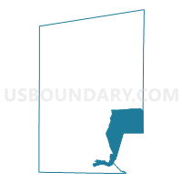
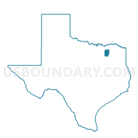
Voting District 0320, Hunt County, Texas
About
Outline

Summary
| Unique Area Identifier | 674929 |
| Name | Voting District 0320 |
| County | Hunt County |
| State | Texas |
| Area (square miles) | 64.35 |
| Land Area (square miles) | 51.58 |
| Water Area (square miles) | 12.77 |
| % of Land Area | 80.15 |
| % of Water Area | 19.85 |
| Latitude of the Internal Point | 32.99113560 |
| Longtitude of the Internal Point | -95.94971230 |
Maps

Graphs
Select a template below for downloading or customizing gragh for Voting District 0320, Hunt County, Texas


Neighbors
Neighoring Voting District (by Name) Neighboring Voting District on the Map
- Voting District 0010, Rains County, TX
- Voting District 0011, Rains County, TX
- Voting District 0016, Hopkins County, TX
- Voting District 0319, Hunt County, TX
- Voting District 0321, Hunt County, TX
- Voting District 0322, Hunt County, TX
- Voting District 0323, Hunt County, TX
- Voting District 0324, Hunt County, TX
- Voting District 0326, Hunt County, TX
Top 10 Neighboring County Subdivision (by Population) Neighboring County Subdivision on the Map
- Greenville CCD, Hunt County, TX (35,498)
- Quinlan CCD, Hunt County, TX (20,969)
- Lone Oak CCD, Hunt County, TX (5,666)
- Point CCD, Rains County, TX (4,516)
- Cumby CCD, Hopkins County, TX (4,263)
Top 10 Neighboring Place (by Population) Neighboring Place on the Map
Top 10 Neighboring Unified School District (by Population) Neighboring Unified School District on the Map
- Quinlan Independent School District, TX (17,815)
- Rains Independent School District, TX (10,518)
- Lone Oak Independent School District, TX (4,337)
- Cumby Independent School District, TX (2,148)
- Miller Grove Independent School District, TX (1,407)
Top 10 Neighboring State Legislative District Lower Chamber (by Population) Neighboring State Legislative District Lower Chamber on the Map
Top 10 Neighboring State Legislative District Upper Chamber (by Population) Neighboring State Legislative District Upper Chamber on the Map
Top 10 Neighboring 111th Congressional District (by Population) Neighboring 111th Congressional District on the Map
Top 10 Neighboring Census Tract (by Population) Neighboring Census Tract on the Map
- Census Tract 9611, Hunt County, TX (6,643)
- Census Tract 9616, Hunt County, TX (6,400)
- Census Tract 9607, Hunt County, TX (5,666)
- Census Tract 9502, Rains County, TX (4,516)
- Census Tract 9502, Hopkins County, TX (4,263)
- Census Tract 9615.03, Hunt County, TX (4,169)
- Census Tract 9617, Hunt County, TX (2,653)
Top 10 Neighboring 5-Digit ZIP Code Tabulation Area (by Population) Neighboring 5-Digit ZIP Code Tabulation Area on the Map
- 75402, TX (15,920)
- 75474, TX (14,882)
- 75169, TX (14,644)
- 75472, TX (3,548)
- 75453, TX (3,255)
- 75422, TX (2,883)
- 75433, TX (2,773)